Tricky outlook with an XL groundswell for Friday

Western Australia Surf Forecast by Craig Brokensha (issued Monday June 5th)
Best Days: Wednesday Perth and Mandurah, Friday, Sunday morning Perth and Mandurah
Features of the Forecast (tl;dr)
- Large, poor quality mix of swells tomorrow with strong SW winds
- Easing surf Wed with strong SW winds in the South West, lighter and offshore in the AM to the north
- Smaller Thu with similar winds to Wed
- XL SW groundswell for Fri with variable NE tending fresher NW winds
- Easing swell Sat with strengthening N/NW tending W/NW winds
- Smaller Sun with variable winds to the north, SW in the South West
Recap
Fun surf across the South West magnets on Saturday with a building, inconsistent SW groundswell with favourable winds for selected spots, poor yesterday with strong N/NW winds.
Perth and Mandurah were tiny, clean Saturday and choppy yesterday.
Today a strong mid-latitude low is moving into us bringing a poor quality increase in localised swell with strong onshore winds and plenty of rain overnight. We'll see the low moving across us today bringing funky S/SE winds to the South West.
This week and weekend (Jun 6 - 11)
In Friday's notes I pointed out that GFS was likely under-cooking the mid-latitude low currently pushing in from the west, with EC being more on target and it looks like we've fallen somewhere in between.
That being not an overly significant system, resulting in a downgrade in the expected size through this afternoon and tomorrow across all locations.
We're seeing a fetch of strong to sub-gale-force W/SW winds pushing in from the west though aimed more into the central and northern regions rather than the metro and South West.
To the south, at the base of the low, gale-force S/SW winds are due to be aimed into us, but all in all, we're only due to see surf in the 10ft+ range in the South West, 3-4ft in Perth and Mandurah along with strong SW winds.
The swell will ease through Wednesday with persistent strong SW winds in the South West, cleaner to the north with light E/NE winds in Perth and S/SE-E/SE winds across Mandurah. Size wise, the metro regions should ease back from 2-3ft.
Thursday will be smaller with winds due to play out similar, onshore and from the W/SW across the South West.
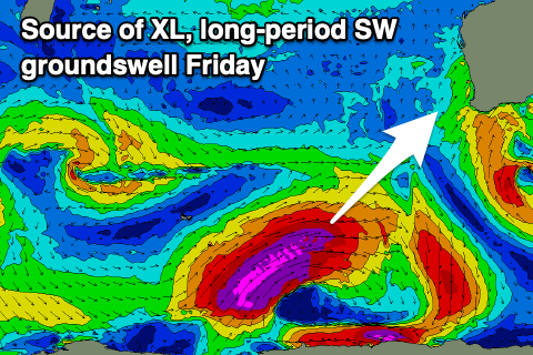
Now, into Friday, an XL long-period SW groundswell is due to fill in, generated by a strong polar low that's formed in the Heard Island region.
A fetch of severe-gale to storm-force W/NW-W winds will initially be generated, weakening slowly while projecting up towards us today and tomorrow.
The slow weakening trend of the low and projection should generate extra-large surf into the end of the week, peaking Friday morning in the 15ft range across the South West magnets, 4-5ft in Mandurah and 3-4ft across Perth.
Winds look to ease and tend lighter N across all locations on Friday morning, likely NE before lunch and NW into the afternoon, with strengthening N/NW tending W/NW winds due to kick in through Saturday as the swell slowly eases. The easing trend will be softened thanks to the slow moving, almost stalling nature of the low
We're expected to see the size continuing to drop through Sunday with persistent SW winds in the South West, cleaner in the morning to the north but small and easing from 1-2ft or so on the sets.
A temporary reprieve between systems is due through early next week, with winds tending NE each morning but with smaller surf. Following this, the next phase of frontal activity is expected to project up and into us mid-late week bringing a renewal of swell and onshore winds, but check back here on Wednesday for more on this.
Comments
Friday looking massive.