Workable tomorrow, then onshore and building

Western Australia Surf Forecast by Craig Brokensha (issued Friday June 2nd)
Best Days: Tomorrow in the South West, Thursday afternoon protected spots, Friday morning
Features of the Forecast (tl;dr)
- Inconsistent SW groundswell building tomorrow with E/NE tending N/NE winds
- Easing swell Sun with strong N/NW tending weaker SW winds late PM
- Building stormy W/NW swell Mon with strong N/NW tending W/NW winds
- Oversized W/SW swell filling in Tue with strong W/SW winds
- Easing large swell Wed with strong SW winds
- Easing surf Thu with gusty SW tending strong S/SE winds
- Large S/SW groundswell building Fri with SE tending S/SW winds
Recap
A mix of swells to 4ft in the South West yesterday with light morning winds and workable conditions, 2ft across Mandurah and 1-2ft in Perth yesterday.
This morning the swell has held in a little to the north and the South West was still seeing 4ft sets early on the magnets.
This weekend and next week (Jun 3 - 9)
Tomorrow will be the pick of the weekend with offshore E/NE tending N/NE winds, likely variable later along with a new, inconsistent SW groundswell building.
With the source being quite a distance away, it'll be a wait for the sets with building waves to 4-5ft on the South West magnets, tiny to the north.
The swell will then ease on Sunday and a weakening frontal system moving in from the west will bring strengthening N/NW winds, shifting weaker SW into the late afternoon.
This frontal system will be an initial, weakening system ahead of a much more significant low, pushing into us while deepening on Sunday afternoon and Monday.
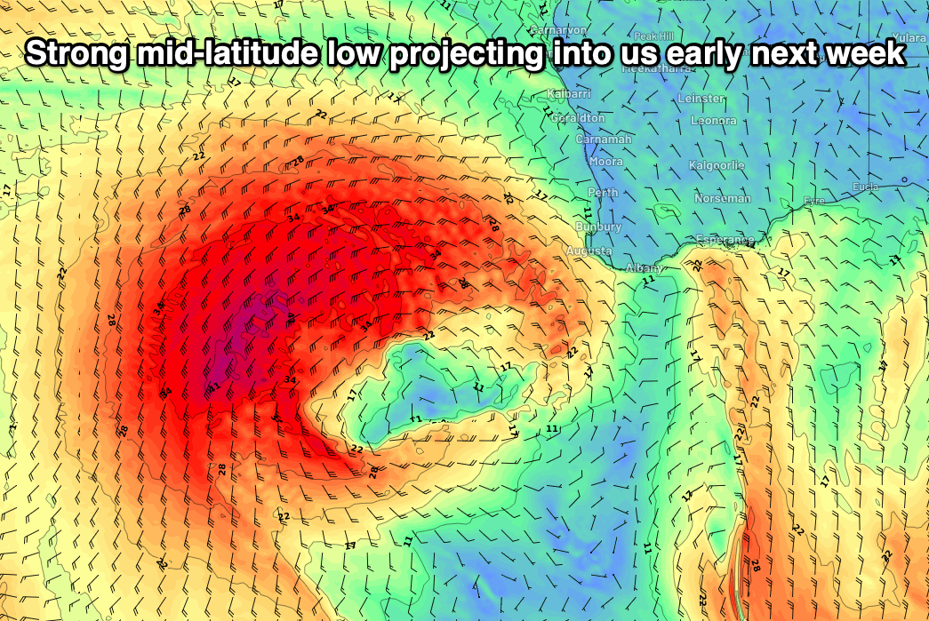
Remarkably the models are still divergent on the strength of this system, but EC has it being significant, and we'll go with this, with an upgrade in the swell models which run on GFS expected over the weekend.
A fetch of gale to severe-gale W/SW winds will project into us on Monday, bringing a building stormy W/NW swell with strong N/NW tending W/NW winds.
Tuesday afternoon will see the peak in oversized W/SW swell coming in at 15ft+ across the South West, 5-6ft in Mandurah and 4-5ft across Perth but with strong W/SW winds.
The low is expected to stall into Wednesday, slowing the easing trend across the state while also bringing persistent, strong SW winds, moving east on Thursday as a secondary strong polar front projects up towards us.
This front will clip the state and be followed by a high, with gusty SW winds due to swing strong S/SE into the afternoon.
This should provide improving conditions in protected spots but with weak, easing 6-8ft surf in the South West, 2-3ft in Mandurah and 2ft across Perth.
The secondary polar front looks to bring with it a large, S/SW groundswell for Friday, with a great fetch of severe-gale S/SW winds pushing east through our swell window.
Surf in the 10ft range is expected in the South West, 2-3ft across Mandurah and 2ft in Perth along with more favourable SE winds. We'll have to confirm this on Monday though as the models are moving around regarding developments from this weekend.
The frontal activity looks to kick back in on Saturday, bringing onshore winds and building surf through the weekend, but we'll have a closer look at this Monday. Have a great weekend!