Tricky period with an oversized, stormy swell next week

Western Australia Surf Forecast by Craig Brokensha (issued Wednesday May 31st)
Best Days: Saturday in the South West, Thursday morning next week Perth and Mandurah
Features of the Forecast (tl;dr)
- Small mix of mid-period S/SW swells tomorrow, biggest into the PM, easing Fri
- Gusty S/SE winds tomorrow, moderate S/SE tending E/SE Fri, then S/SE into the PM
- Inconsistent SW groundswell filling in Sat, peaking in the PM with moderate E/NE tending N/NE winds
- Easing surf Sun with strong N/NW tending W/SW winds
- Stormy surf building Mon with strong NW tending W/NW winds, oversized Tue with strong W/SW winds
- Easing surf Wed with strong SW winds
Recap
Average surf across all coasts yesterday with a weak, bumpy N/NW windswell in Perth and Mandurah, choppy and poor across the South West with strong W/NW-NW winds.
Today, the trough linked to the poor winds and surf has cleared to the east, bringing cleaner conditions and an easing mid-period W/SW swell to 3-4ft in the South West, 2ft in Mandurah and 1-2ft across Perth.
This week and next (Jun 1 - 9)
Looking at tomorrow and we've got a small mix of weak S/SW swells on the cards. The first will be locally produced today and have no size, while a strengthening polar frontal progression that formed late in our swell window yesterday will generate a more noticeable increase.
It might be undersized at dawn but a kick to 3ft to occasionally 4ft is due across the South West magnets, tiny to the north, easing back from 3ft on Friday.
Unfortunately gusty S/SE winds will create average conditions tomorrow, slightly better Friday and S/SE tending E/SE before reverting back to the S/SE into the afternoon.
Winds will shift E/NE on Saturday morning and then N/NE through the day along with a building, inconsistent SW groundswell. The source of this swell was a strong polar low west of the Heard Island region and it'll be inconsistent with sets to 4-5ft due to develop through the day, fading back from 3ft or so on Sunday. Conditions will be poor on Sunday though with strong N/NW tending W/SW winds as a weakening cold front pushes up and into the state.
Now, this front will be the first in a series of strong mid-latitude storms that will fire up towards us, under the influence of the Long Wave Trough.
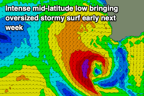
An initial flurry of mid-latitude fronts will generate fetches of strong to gale-force W/SW winds through our western swell window, with the second strongest front then spawning into a strong mid-latitude low south-west of us Sunday evening.
The low will generate severe-gale-force winds and a mix of oversized, stormy waves will develop Monday afternoon, peaking Tuesday.
We're looking at easy 15ft surf in the South West, if not bigger with stormy 4-6ft waves in Mandurah and 3-5ft across Perth along with strong W/SW winds.
The size is due to ease back Wednesday as winds shift SW but remain strong, cleaning up to the north Thursday/Friday but with smaller, easing surf.
Further frontal activity is on the cards into next weekend and the following week but we'll look at this in more detail on Friday.
Comments
I was hoping that we would be getting less mid level rubbish now that we are going into el nino. Doesn’t seem to be the case.
I don't think fwe'll 'see' that until late winter-spring and really summer but Craig's the expert
Yep, as T-diddy has pointed out, looks like for Western Australia it won't be until spring time that the fronts back off along with the reduction in rainfall. Winter is always going to be plagued by these kind of systems.
Will get back to ya's during the day.
Actually nice east winds at Margs yesterday Craig, got strong in the arvo but stayed offshore se, squashed low so onshore either end of the capes but offshore at Margs, a weird little pattern that occurs more often than you would think during the winter months
Yeah funky pattern with the trough, looked nice into the arvo and eve!