Building surf with onshore winds

Western Australia Surf Forecast by Craig Brokensha (issued Monday April 10th)
Best Days: Possibly early Wednesday Perth/Mandurah, Saturday and Sunday mornings Perth/Mandurah
Features of the Forecast (tl;dr)
- Large SW groundswell tomorrow with strong but abating SW winds
- Moderate sized W/SW swell for tomorrow
- Drop in swell Wed AM with strengthening NW winds (possibly N/NE early Perth/Mandurah)
- Larger building mix of swells Thu with strong NW tending W/SW winds
- Oversized mix of swells developing Fri with strong S/SW winds, easing slowly Sat
- Strong S/SW winds Sat (possible S/SE Perth/Mandurah)
- Smaller Sun with strengthening W/NW winds (light E Perth/Mandurah early)
Recap
Great conditions with a drop in swell from Friday, easing back from 3-4ft in the South West on Saturday with 1-2ft sets in Mandurah and 1ft waves across Perth.
A temporary low point in swell was seen yesterday morning ahead of our new SW groundswell into the late morning, offering good waves ahead of late sea breezes. Today the swell has faded and winds have quickly strengthened from the N/NW ahead of a strengthening mid-latitude front.
This week and weekend (Apr 11 - 16)
Choppy and onshore. That's the short of it.
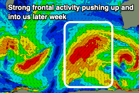
We've got a prolonged period of onshore winds and large, stormy surf across the South West thanks to a stalling node of the Long Wave Trough across us for the next week and a half.
This will steer and strengthen Southern Ocean frontal activity up and into us, generating plenty of swell but also bringing the winds with it.
There'll be a couple of windows of cleaner conditions in Perth and Mandurah and these will be worth targeting over anything in the South West.
Looking at today and the first system is strengthening on approach, with it being a tight mid-latitude low, followed by a stronger polar front from the south-west.
This front will spoil conditions tomorrow with strong pre-dawn SW winds due to ease as the sun rises but remain onshore. A large SW groundswell generated by the earlier stages of the front should provide 6ft+ sets in the South West, with 2-3ft of weak mid-period W/SW swell in Perth and Mandurah.
A larger SW groundswell should be seen on Wednesday afternoon, but with freshening NW winds ahead of the next frontal system. Perth and Mandurah are an outside chance for dawn N/NE winds along with a mix of swells to 2ft+.
The frontal system will near closer on Thursday bringing strong NW winds ahead of a W/SW change as it pushes into us, along with even larger surf.
Building sets to 10ft are due in the South West, 3ft Perth and Mandurah ahead of an oversized stormy swell Friday afternoon/Saturday to the 12-15ft range in the South West, 3-5ft in Mandurah and the 3-4ft range in Perth. Strong S/SW winds may provide novelty options on Friday with Saturday possibly seeing S/SE winds in Perth and Mandurah with the oversized (but easing), localised swell.
There'll be little to no real let up in the onshore breeze across the South West with more frontal activity due to move in through next week but without the strength of this week's storms. More on this in Wednesday's update.