Good swell for tomorrow with favourable winds

Western Australia Surf Forecast by Craig Brokensha (issued Monday March 13th)
Best Days: Tomorrow, dawn Wednesday, Friday morning Perth and Mandurah, Sunday morning, Monday morning
Features of the Forecast (tl;dr)
- Large SW swell peaking tomorrow with light E winds in the South West (S/SE-SE in the north) ahead of relatively weak sea breezes
- Easing swell Wed with early variable winds, shifting onshore
- Poor Thu with strong N/NW tending W/SW-SW winds (N/NE early Perth and Mandurah)
- Weak W/SW swell Fri AM with strong S/SW-S winds in the South West, S/SE in the AM
- Small Sat with E/SE-E winds ahead of sea breezes
- Mod-large S/SW groundswell building Sun, peaking later, easing Mon
- E/SE-E winds with sea breezes Sun, fresh E/NE Mon AM
Recap
Fun surf on Saturday across the South West with a small, background swell in the 3ft+ range, smaller yesterday but clean again through the morning. Perth and Mandurah were clean but tiny.
This morning there's been a small lift in weak swell across the South West along with light winds and we should see the size increase further during the day as a moderate-large mid-period SW swell arrives. Sea breezes will create average conditions though.
This week and weekend (Mar 14 - 19)
This afternoon's increase in swell will peak tomorrow, generated by a healthy but not overly strong frontal system pushing towards us from the Heard Island region late last week.
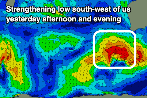
The frontal system is now deepening into a stronger low to the south of us, with it generating a fetch of stronger gales just before pushing too far east of our swell window.
This should help provide more consistent 8ft sets tomorrow when it peaks across the South West (6-8ft generally), while Mandurah should come in at 2-3ft with 2ft surf in Perth.
Winds look good and light offshore out of the E across the South West, S/SE-SE further north and sea breezes look to come in generally weak.
Wednesday morning should still provide some good sized sets, but easing steadily with early 4-6ft waves on the magnets, 2ft Mandurah and 1-2ft across Perth.
Winds on Wednesday look a touch dicey but should be variable early before shifting onshore during the day and then stronger from the N/NW Thursday morning ahead of a W/SW change. Perth and Mandurah should be cleaner early on Thursday morning but small to tiny.
There should be a small, local increasing in mid-period W/SW swell from the trough/low bringing Thursday's change, favouring Perth and Mandurah into Friday morning as winds shift S/SE.
Expect peaky 2ft offerings while the South West looks choppy and to 4-5ft or so with strong S-S/SW winds.
A high will move in on the weekend, swinging winds back offshore and with a good pulse of new, mid-period S/SW swell.
The source of this swell will be a relatively weak but slow moving and persistent polar low forming to the west of the Heard Island region tomorrow, then projecting slowly east while generating a fetch of strong to gale-force W'ly winds.

A moderate-large S/SW groundswell should be created, with it building through Sunday and reaching 6ft to occasionally 8ft through the late afternoon/evening, then easing from the 6ft range Monday. Mandurah should build to 2ft+ and ease from a similar size Monday morning with 1-2ft sets in Perth.
As touched on above, locally winds look good with E/SE-E offshores both Saturday and Sunday mornings, E/NE on Monday morning ahead of a trough. This trough may bring a return to S/SE breezes on Tuesday but we'll confirm this on Wednesday.
For the rest of the week, continued polar frontal activity to our south should generate fun sized pulses of S/SW swell for the rest of the week with morning SE winds. More on this Wednesday though.