Fading surf, with a new swell for early next week

Western Australia Surf Forecast by Craig Brokensha (issued Wednesday January 18th)
Best Days: This morning in the South West, desperate surfers tomorrow morning in the South West, protected spots Tuesday, South West Wednesday morning
Features of the Forecast (tl;dr)
- Easing surf Wed, Thu and Fri with E/SE morning winds (strongest Wed AM) ahead of strong sea breezes
- Small mid-period SW swell for later Fri, easing Sat with fresh SE tending strong S/SW-SW winds
- Inconsistent, moderate sized SW groundswell building Mon PM, peaking Tue, easing Wed
- Strong S/SE tending S/SW winds Mon, strong S/SE winds Tue and fresh SE tending S/SE winds Wed
Recap
A good pulse of size across the South West through yesterday with a new mid-period SW swell kicking to 6ft+ through the day along with morning SE winds. Perth and Mandurah were small to tiny and best later morning and early afternoon ahead of sea breezes.
The swell has eased into this morning under a strong but easing E/SE offshore in the South West along with 4-5ft sets, while to the north we've got clean tiny 1-1.5ft waves.


Yesterday PM (top) and this AM (bottom)
This week and next (Jan 19- 27)
Down, down, down. We've got easing surf over the coming days so make the most of this morning's waves in the South West as tomorrow looks to be smaller and easing from 2-3ft. It'll be windy but clean with a gusty E/SE offshore, easing through the morning before stronger S/SE breezes kick in.
Friday looks smaller again and clean but with nowhere to recommend.
SE winds are due each morning on the weekend but swell wise, there's nothing significant due at all. The South West should see a small pulse of background SW swell later Friday, easing Saturday from 2-3ft, tiny Sunday.
Moving into next week and our moderate sized SW groundswell is due to build on Monday ahead of a secondary pulse and peak through Tuesday. These swells are being generated by a healthy and upgraded polar low that's formed to the south of South Africa.
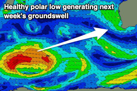
The low is currently strengthening today, generating a fetch of W/SW gales that will persist into tomorrow morning before easing into the evening. The slow moving nature of the low and persistent fetch should generate a moderate sized SW groundswell with building surf Monday afternoon to 4-5ft in the South West, peaking Tuesday to 4-6ft.
Mandurah is only due to see slow 1ft to maybe 2ft sets, 1-1.5ft in Perth on Tuesday.
Local winds aren't great unfortunately as a trough moves in later Sunday bringing strengthening S/SE winds to the South West on Monday and variable tending NW winds to the north. Tuesday looks similar with strong morning S/SE winds ahead of S/SW sea breezes.
As the swell eases on Wednesday we should see winds tip more SE in the morning, cleaner Thursday but small and fading.
Longer term the Southern Ocean looks to become quiet with nothing too major on the cards but check back here on Friday for more on this.