Good quality swells with workable winds

Western Australia Surf Forecast by Craig Brokensha (issued Wednesday December 21st)
Best Days: Today in the South West, tomorrow morning all locations, Friday morning in the South West, Sunday mid-late morning protected spots, Monday protected spots, Wednesday protected spots, Thursday morning in the South West
Features of the Forecast (tl;dr)
- Large mix of SW groundswells building today, easing Thu
- Gusty SE-E/SE winds Thu ahead of S/SW sea breezes (E tending SW to the north)
- Easing surf Fri and Sat with morning S/SE-E winds and afternoon sea breezes
- Oversized SW groundswell building rapidly Sun with S/SE tending S/SW-SW winds, easing Mon with S/SE tending S/SW-SW
- Easing swell Tue with early S/SE winds
- Reinforcing mid-period SW swell Wed with strong S/SE winds, easing Thu with morning SE winds
Recap
The swell held in at a good 5ft through yesterday with favourable winds at dawn across the South West, deteriorating a touch through the morning ahead of sea breezes. Today we’ve got long new lines of groundswell on the build with clean conditions again and sets to 5-6ft. Further north, Perth and Mandurah have remained tiny.

Straight lines of long-period SW groundswell this AM
This week and next week (Dec 22 - 30)
Today’s mix of long-period SW groundswells should reach a good 6-8ft across the South West with 2ft sets in Mandurah and 1-2ft waves across Perth though with sea breezes.
Tomorrow morning should come in at a similar size, easing through the day and winds will be good, E/SE-SE through the morning and fresh before strong sea breezes kick in.
The swell will ease slowly Friday, further Saturday and winds will become less favourable and from the S/SE-SE through the mornings. Try semi-protected spots in the South West.
Moving into Sunday, we’re set to see a large, rapid increase in oversized SW groundswell, with it set to arrive shortly after dawn in the South West.
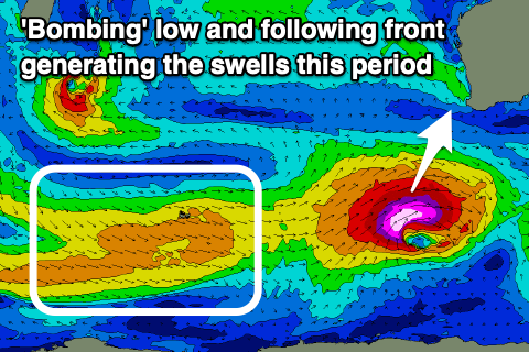
As talked about in Monday’s update, a significant, ‘bombing’ low is forecast to form to the south-west of us during the end of the week. A ‘bombing’ low is one which drops at least 24hPa within a 24 hour period and this will do so during Friday as a tropical depression gets dragged down into the westerly storm track from Madagscar.
As a result, we’ll see a significant fetch of storm-force W/SW winds projected through our south-western swell window, forming a touch later than ideal.
This will likely result in slightly less size across the South West, but still an easy 12ft+ with 15ft sets across the deepwater reefs. Mandurah should build to 4ft on the sets with 3ft waves across Perth into the afternoon.
The only issue are the local winds, with morning SE-S/SE breezes due to give into strong sea breezes when the swell really kicks in, better Monday morning as it eased back from a little smaller in size. Moderate S/SE winds will favour protected spots ahead of strong S/SW sea breezes from late morning.
Similar winds are due on Tuesday as the swell continues to ease, dropping back from the 5-6ft range in the South West, 2ft in Mandurah and 1-2ft across Perth. Into the afternoon and more so Wednesday, a reinforcing pulse of mid-period SW swell is due, generated by a much weaker front following the ‘bombing’ low.
This will generate 5-6ft surf through Wednesday across the South West, 2ft in Mandurah on the sets and 1-2ft across Perth as winds strengthen from the S/SE. This isn’t ideal with cleaner conditions due as it eases into Thursday but we’ll have a closer look at this Friday.