Average surf, improving from Sunday

Western Australia Surf Forecast by Craig Brokensha (issued Wednesday November 23rd)
Best Days: Sunday morning in the South West, Monday morning in the South West, Tuesday morning in the South West, Wednesday morning
Features of the Forecast (tl;dr)
- W-W/SW winds on Thu, lighter and more variable Fri AM, freshening from the W/SW
- Small weak SW swell Fri
- Smaller Sat with S/SE tending S/SW winds
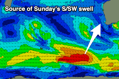
- Fun new mid-period S/SW swell Sun with mod-fresh SE tending S/SW winds, smaller Mon with E/SE-SE tending S/SW winds
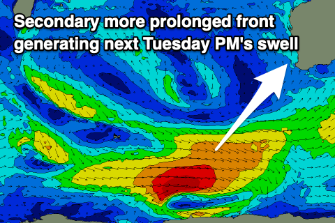
- Moderate sized + S/SW groundswell for Tue PM with SE tending strong S/SW winds, easing Wed with E/SE tending S/SW winds
- Possible secondary S/SW groundswell for Thu
Recap
Clean conditions yesterday morning though blowy with easing 3-4ft sets on the magnets, tiny in Perth and Mandurah. This morning conditions were clean again but the swell reaching a low point.
This week and next (Nov 24 - 27)
A weak low that's formed west of us is now moving east, bringing an onshore change to all locations this afternoon, and we'll see a secondary weak low backing it up tomorrow, maintaining onshore winds across the South West. They'll only be light and from the W/SW-W but the main issue will be the lack of decent swell.
It won't be until the late afternoon but more so Friday and the source is weak in any case.
There'll be no size in Perth or Mandurah, with a weak local windswell to 1-1.5ft, and 3-4ft across the South West max, easing through the day.
 We may see more variable winds early Friday morning ahead of a freshening W-W/SW breeze, creating cleaner conditions but the size will be minimal, as stated above.
Moving into Saturday, small surf looks to persist across the South West with improving, S/SE morning winds, but Sunday will be better with a new mid-period S/SW swell and a moderate to fresh SE breeze.
This swell won't offer any major size, with it generated by a fetch of pre-frontal, sub-gale-force W/NW winds moving through our swell window today, but a fun kick to 4-5ft on the South West magnets should be seen Sunday, tiny to the north.
Monday looks cleaner but smaller with easing 3-4ft surf and a morning E/SE-SE offshore.
 Looking at the rest of the week and a couple of stronger fronts skirting around the the base of a strong high to our south-west should generate some larger surf for Tuesday afternoon and Thursday.
The first will form west of the Heard Island region tomorrow, generating a good fetch of pre-frontal W/NW gales that will continue east and tend W'ly to our south-southwest while weakening slightly. We may see a final late intensification but regardless a moderate-large S/SW groundswell is due Tuesday afternoon from this source, kicking to 6ft+ in the South West with inconsistent 2ft sets in Mandurah and Perth.
A morning SE breeze will create clean conditions as the swell builds, but strong sea breezes are due when it peaks, with Wednesday seeing better conditions under an E/SE offshore as the swell eases.
Longer term we may see a secondary strong low generating another pulse of S/SW groundswell for Thursday, but check back here on Friday for a clearer idea on this.