Fun surf over the coming days, strong swell for the weekend

Western Australia Surf Forecast by Craig Brokensha (issued Monday August 22nd)
Best Days: Tomorrow, Wednesday and Thursday in the South West, Perth and Mandurah Sunday morning, Monday, Tuesday
Features of the Forecast (tl;dr)
- Easing SW groundswell with gusty E tending lighter E/NE winds tomorrow, smaller Wed with strong E/NE tending weaker E/NE-NE winds
- Small, mid-period SW swell Thu, easing Fri with E/NE tending variable N winds Thu, S/SE tending SW Fri
- Strong S/SW winds Sat with a new mid-period SW swell (S/SE in the AM further north)
- XL, long-period SW groundswell filling in Sun, peaking in the PM with S/SW winds in the South West, E/SE-SE further north
- Large, easing swell Mon with E/NE tending N winds
Recap
An improvement in conditions across the South West on Saturday with more variable winds and a fun, reinforcing mid-period SW swell to 4-6ft. Perth and Mandurah were great with clean conditions and 2ft sets across the former, and 2-3ft waves across the latter.
Yesterday was smaller and poor with onshore winds across the South West, small to tiny further north but cleaner.
Today our new pulse of SW groundswell has filled in, a little undersize at dawn but now 6-8ft across the South West magnets with 2ft sets in Mandurah and tiny waves across Perth, increasing a touch now to 1-1.5ft. Conditions will remain good all day with persistent offshore winds.


Perfect waves in between cleanups
This week and weekend (Aug 23 - 28)
Following today's peak in SW groundswell across the state, it'll be down in size steadily through tomorrow and Wednesday ahead of small pulse of reinforcing SW swell on Thursday.
A strong high pressure system that's currently edging in from the west will see winds swing more E'ly tomorrow, gusty through the morning and then lighter E/NE into the afternoon.
Expect easing sets from 4-6ft in the South West on the magnets, 2ft in Mandurah and 1-1.5ft across Perth.
 Wednesday will only be surfable in the South West with smaller leftover waves and strong E/NE tending weaker E/NE-NE breezes.
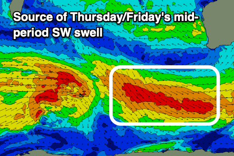
Into Thursday, a small pulse of new mid-period SW swell is due, generated by a broad but not overly well aimed fetch of strong to gale-force W/NW winds swinging in through our swell window, south-west of us over the coming days.
We should see fun 4ft sets spreading radially up and into us on Thursday, easing Friday from a similar size with tiny waves further north in Perth and Mandurah.
An E/NE tending variable N wind will favour the South West magnets on Thursday with a trough bringing S/SE tending SW winds on Friday.
Now, moving into the weekend we've got a mix of new mid-period SW swell Saturday and XL, long-period SW groundswell for Sunday afternoon.
Saturday's will be generated by a relatively weak polar low, with a much stronger, broader and longer lived system due to form behind it. This secondary low will generate a pre-frontal fetch of gale to severe-gale W/NW winds followed by stronger severe-gale to storm-force W/SW winds around the core of the low.
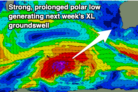 This low is forecast to project ideally north-east up towards us through the end of the week, generating an XL, long-period groundswell that's due to peak through the afternoon in the South West, Perth and Mandurah.
With the low pushing up towards us, it'll bring strong S/SW winds on Saturday with the new mid-period swell, improving Sunday as a high starts to edge in. Unfortunately it looks like moderate to fresh S/SW winds will persist across Margs, cleaner to the north with an E/SE-SE offshore.
Margs should see the swell building to 12ft to possibly 15ft with 3-4ft sets in Mandurah and 3ft sets across Perth, easing Monday from 10ft+, 3ft and 2ft+ respectively with light offshore winds and weak sea breezes.
Following this another good, large SW groundswell is likely Thursday next week with light winds but we'll have a closer look at this on Wednesday.