Tricky period of winds and swell

Western Australia Surf Forecast by Craig Brokensha (issued Friday August 12th)
Best Days: Perth and Mandurah Sunday morning, Perth and Mandurah Wednesday morning and Friday, protected spots in the South West Friday
Features of the Forecast (tl;dr)
- Low point in swell tomorrow with strong N/NE tending NW winds late PM
- Large W/SW groundswell peaking Sun AM, easing into the PM and further Mon
- Small-moderate sized mid-period SE swell for the South Coast Sun
- Moderate W/NW tending N/NW winds in the South West Sun, E/NE-NE tending N/NW in Perth and Mandurah
- Easing surf Mon with strong N/NE tending N/NW winds
- Weak mid-period W/SW swell Tue and Wed with gusty W/SW winds
- Larger swell likely later week with S/SE winds
Recap
Great surf across all locations yesterday with a further drop in swell but good conditions all day with an afternoon glass off seen across most breaks. Today is smaller but surfable early across the magnets before the northerly got up.

LAGO in the South West yesterday
This weekend and next week (Aug 13 - 19)
We've got a poor weekend of surf ahead in the South West but we should see good surf in Perth and Mandurah as winds go variable E/NE Sunday morning.
Tomorrow will be a lay day with a low point in swell and windy conditions, strong from the N/NE in the morning, shifting NW later afternoon and then W into the evening as a strong trough moves across us.
The trough will slide away to the south-east on Sunday allowing winds to tend variable from the E/NE-NE in Perth and Mandurah, lingering from the W/NW in the South West.
 Our large W/SW groundswell is on track, generated by a strong low projecting north of the Heard Island region mid-late this week.
Sets to 10ft are due across the South West, 3-4ft in Mandurah and 3ft in Perth. The swell is due to ease through the day, with smaller waves into Monday (2-3ft Mandurah and 2ft Perth) as winds strengthen from the N/NE and tend N/NW into the afternoon ahead of the next front.
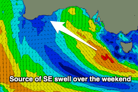
On a side note there'll be some decent sized SE swell in the mix again across the exposed southern coasts this weekend, generated by a fetch of strong to gale-force SE winds west of Tasmania last night and today.
Now, as touched on in Wednesday's update the follow up swells for next week weren't looking to be too reliable with the European forecasting models suggesting more trough activity instead of proper cold fronts as suggested by GFS, the American solution. This has turned out to be the case, with Monday's trough due to slip through Tuesday bringing a strong W/SW change but no major increase in swell.
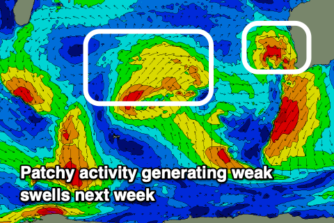 What we're looking at is various pulses of mid-period W/SW and SW swell from Tuesday through the end of the week, with the largest increase in size due Thursday/Friday as one of the strongest fronts clips the state.
Winds will be poor across the South West and W'ly on Wednesday with strong W tending S winds on Thursday as the front clips us. Slightly more favourable S/SE breezes may be seen on Friday but we'll have to go over this again on Monday. Perth and Mandurah should see windows of more favourable winds on Wednesday and Friday but again check back Monday for confirmation.
Size wise Margs looks only yo be 4-6ft Tuesday and Wednesday, 2ft across Mandurah and 1-2ft in Perth, with the large swell Thursday afternoon/Friday morning coming in at 8-10ft, 3ft and 2-3ft respectively.
Longer term we may see a larger, stronger and better SW groundswell developing for late next weekend/early the following week but check back Monday for more on this. Have a great weekend!