Limited windows for a clean wave

Western Australia Surf Forecast by Craig Brokensha (issued Friday August 5th)
Best Days: Perth and Mandurah Wednesday morning, Margs Thursday
Features of the Forecast (tl;dr)
- Fun S/SE groundswell tomorrow across the south with strengthening NW winds
- Low point in swell elsewhere
- Moderate sized SW groundswell Sun with fresh W/SW tending W/NW winds
- Mix of new mid-period swell Mon and localised windswell with strong NW tending W/SW winds
- Large W/SW groundswell Tue with strong S/SW winds
- Easing swell Wed with fresh S/SW winds (E/NE Perth and Mandurah)
- Small fading surf Thu with E'ly winds in the South West
Recap
Conditions across most locations were still pretty ragged and large yesterday, best in protected spots and cleanest across Mandurah with Perth remaining quite wind affected through the day.
Cleaner conditions have been seen today in the metro regions with peaky, fun 2-3ft sets in Mandurah, 2ft across Perth a bumpy 4-6ft across Margs.

Good surf for the early in Perth
This week and weekend (Aug 6 - 12)
 Tomorrow will be poor as the swell continues to ease and winds strengthen from the NW ahead of an approaching front.
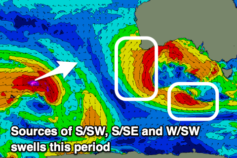
The South Coast is still expected to see a fun S/SE swell, generated by strong to gale-force S/SE winds wrapping around the southern flank of the slow moving, multi-threaded low pushing across us this week. With this combo of swell and winds there should be some fun options.
Later in the day tomorrow a new pulse of groundswell is due, peaking Sunday, generated by a short-lived fetch of W/SW gales through our swell window on Wednesday. 5-6ft sets are due across the South West with 2ft waves in Mandurah and 1-2ft waves in Perth but with fresh W/SW tending W/NW winds.
 These onshore winds will be linked to slow moving but weakening mid-latitude low moving in from the west.
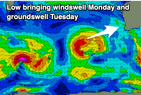
This low will generate fetches of strong to gale-force W/SW winds while approaching from the south-west, passing across us Monday bringing strong NW tending W/SW-SW winds. This will continue to create poor conditions across both regions while kicking up some localised windswell ahead of the groundswell from the low on Tuesday.
There'll also be some mid-period swell in the mix on Monday but with the onshore wind conditions will be poor. Margs should increase to 6ft+ with 2-3ft waves in Mandurah and 2ft+ surf across Perth.
Tuesday looks to come in around the 10ft range across the South West, 3ft in Mandurah and 2-3ft in Perth along with strong S/SW winds in the wake of the low which will be weakening into a trough.
 Unfortunately the slow movement of the trough looks to leave lingering S/SW winds across the South West on Wednesday as the swell starts to ease, cleaner in Perth and Mandurah with light E'ly breezes. Easing 2ft+ waves are due across Mandurah with 1-2ft sets in Perth.
Thursday looks the best across the South West but size wise easing surf from a smaller 3-5ft is likely.
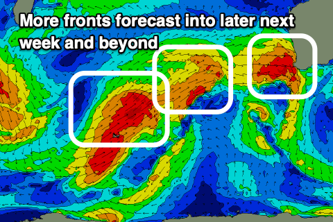
Longer term it'll only be a temporary reprieve from the onshore winds and fronts before the next episode of storms start moving up and into us late next week. This will bring another run of poor conditions and large stormy conditions. More on this Monday, have a great weekend!