Easing winds and abating swell

Western Australia Surf Forecast by Craig Brokensha (issued Wednesday August 3rd)
Best Days: Protected spots all breaks tomorrow morning, Friday morning (Margs lower expectations), Perth and Mandurah Sunday morning
Features of the Forecast (tl;dr)
- Large easing W/SW tending SW swell tomorrow with strong S/SW winds in the South West. Fresh S-S/SE tending SW Perth and Mandurah (possibly light SE Perth mid-late AM)
- Easing S/SW swell Fri with E/NE tending light NW winds Perth and Mandurah, S-S/SE tending W/SW Margs
- Fun S/SE groundswell Sat across the south with N/NW winds
- Low point in swell elsewhere Sat with strengthening N/NW winds (N/NE early Perth and Manudrah)
- Moderate sized SW groundswell Sun with fresh W winds in Margs, variable Perth and Mandurah early
- XL building stormy swell Mon with strong W/SW tending SW winds
- Easing XL swell Tue with strong but easing S/SW winds
Recap
XXL stormy conditions across the South West the last two days with gale-force winds, large across Mandurah with nowhere to recommend and maxing in Perth with the outer reefs breaking regularly.

Maxing conditions yesterday AM
This week and weekend (Aug 4 - 7)
The broad low pressure gyre with multiple frontal systems spinning around it, slamming them into us, is due to slowly push east over the coming days, swinging winds more S/SW tomorrow as the backside of the gyre impacts us.
Strong S/SW winds will continue to create poor conditions in the South West but with the large, easing swell protected spots should offer something before the swell starts shifting more south in direction. Easing sets from 10ft+ are due in the morning.
Perth and Mandurah should see S-S/SE breezes, possibly tending light SE through the morning across Perth and with easing sets from 4ft in Mandurah, 3ft across Perth.
 Moving into Friday the swell will come from a S/SW direction owing to strong to gale-force S'ly winds being aimed through our swell window this afternoon and evening.
The South West looks to be still in the 6ft range through the morning before easing through the day, small into Saturday.
Perth and Mandurah will be smaller with 2-3ft sets across Mandurah, 2ft in Perth as winds swing light E/NE in the morning ahead of weak NW sea breezes. Margs may see early light S/SE winds, shifting W/SW through the day providing OK conditions for keen surfers.
For those across the southern regions, keep an eye out for some moderate sized S/SE groundswell Saturday from a slow moving fetch of S/SE gales on the bottom of the gyre over the coming days. N/NW winds should also open up plenty of options.
Coming back to the South West and metro regions, Saturday will be poor as the swell bottoms out along with strengthening NW winds (N/NE early Perth and Mandurah).
A new pulse of SW groundswell is due to arrive on dark Saturday and peak Sunday, followed by reinforcing mid-period energy on Monday.
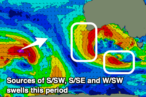
The source of this swells will be a polar low forming today in the Heard Island region. An initial burst of W/SW gales will be followed by a broader but weaker fetch of W/SW winds and size wise the South West should see 5-6ft sets on Sunday, 2ft in Mandurah and 1-2ft across Perth but with gusty W-W/NW winds. Perth and Mandurah look OK early with variable breezes.
Stronger W/SW tending SW winds will spoil Monday's swell but also be attached to a deepening low directly south-west of us. This looks to bring another XL episode of stormy onshore surf with strong onshore winds, building Monday and peaking Tuesday morning.
Conditions will be a mess during the peak but possibly improve mid-next week as it eases though we'll have to have a closer look at this on Friday.