Wild, wooly week ahead

Western Australia Surf Forecast by Craig Brokensha (issued Monday August 1st)
Best Days: Friday morning Perth and Mandurah
Features of the Forecast (tl;dr)
- XL W/SW swell tomorrow and Wed with strong to gale-force (in the South West) W winds tomorrow, strong W/SW on Wed
- Easing large surf Thu with strong S/SW winds
- Smaller, leftover waves easing Fri with E/NE tending NW winds (W/SW in the South West)
- Moderate sized + SW swell building Sun with W/SW tending strong W/NW winds
- Easing surf Mon with strong W/NW tending SW winds
Recap
XL stormy surf on the weekend across the South West, similar in Perth and Mandurah Saturday but cleaner and better yesterday with plenty of left over size.
Today conditions are again deteriorating with morning N winds, shifting NW and strengthening as a significant frontal system moves in from the west.
This week and weekend (Aug 2 - 7)
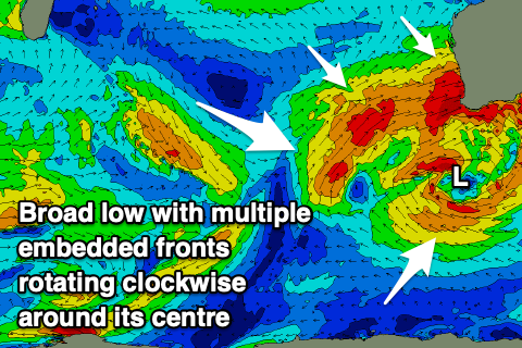
Looking at the current synoptic setup and we're set to get slammed by cold fronts, swell and weather over the coming days.
This is thanks to a broad, multi-centred low pressure system moving east across us, bringing persistent onshore winds and XL, stormy surf.
Winds will continue to strengthen out of the W/NW this evening as the strongest of the fronts approaches, with gale-force winds due in the South West, shifting W tomorrow morning ahead of another similar strengthen front tomorrow evening.
 The earlier stages of the frontal progression in the Indian Ocean late last week and through the weekend have generated some XL W/SW swell, with the South West due to come in around 15ft tomorrow, 5-6ft across Mandurah and 4-5ft in Perth.
The secondary front will project more XL swell producing winds into us Wednesday, maintaining similar sized surf in the South West, 4-6ft in Mandurah and 3-5ft across Perth but with strong W/SW winds.
The low will take its time clearing west, with unfavourable, strong S/SW winds due into Thursday as the size starts abating.
Friday looks to be the pick of the week as winds ease further, shifting light offshore from the E/NE in Perth and Mandurah while likely persisting from the W/SW in Margs.
Size wise, easing levels of mid-period energy is expected, much smaller than what'll be seen through the week. The South West should ease back from 4-6ft in the South West, 2ft Mandurah and 1-2ft in Perth.
Some new mid-period SW swell is due to build into the weekend (mostly Sunday) generated by a broad but weak polar front that'll develop around the Heard Island region early Thursday.
A slow moving fetch of strong W/SW winds should generate 6ft+ of swell for the South West Sunday afternoon and 2ft+ in Mandurah (1-2ft Perth) but the remnants of this low are due to push up and into us on the weekend. This will bring strengthening NW winds on Saturday, shifting W/SW Sunday morning ahead of another front and W/NW winds into the afternoon.
Monday looks onshore as the swell eases but the models diverge regarding the frontal activity early next week. So check back Wednesday for a clearer idea.
Longer term more frontal activity is due into next week and beyond, but we'll go over this again next update.