Small wave options on the weekend, larger onshore surf next week

Western Australia Surf Forecast by Craig Brokensha (issued Friday April 22nd)
Best Days: South West swell magnets tomorrow afternoon, selected spots Monday, Friday morning Perth and Mandurah
Features of the Forecast (tl;dr)
- Inconsistent, small SW groundswell Sat (possibly undersized at dawn) with strong E/NE winds, easing and tending variable late
- Easing SW groundswell Sun with gusty E/NE tending lighter N/NE winds
- Moderate sized + W groundswell filling in Mon with moderate freshening NE tending N/NW winds, W/NW later
- Easing surf Tue with strong but easing W/SW-SW winds
- Stormy swell Wed with strengthening W winds
- Large mid-period S/SW swell building Thu with strong SW tending S/SW winds
- Large S/SW groundswell Fri with W winds in the South West (NE in the morning Perth and Mandurah)
- Easing swell Sat with possibly lighter winds
Recap
Tiny surf in Perth and Mandurah yesterday but great conditions across the South West with a reinforcing S/SW groundswell to 4-5ft+, easing slowly through the day. Today the swell is smaller but still fun and to 3ft+ on the magnets.

Decent sets yesterday morning
This weekend and next week (Apr 23 - 29)
The weekend will be slow but tomorrow should be surfable across the magnets in the South West as a new, inconsistent SW groundswell fills in.
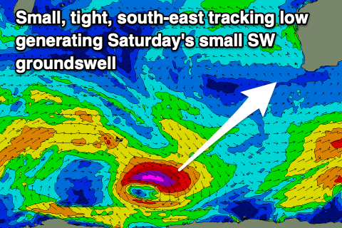 This was generated by a strong but tight and south-east tracking low that developed south-east of the Heard Island region during the week.
Inconsistent 3-4ft sets are due in the South West, possibly a touch undersized early and winds will be strong from the E/NE but improving through the day, easing into the afternoon and tending variable late.
Come Sunday the swell will be on the ease from 2-3ft with gusty E/NE tending lighter N/NE winds into the afternoon.
Looking into next week and we'll enter the first real winter blast of the year as a progression of strengthening mid-latitude storms push up and across us, bringing large stormy surf that will persist into next weekend.
Firstly though, we've got our moderate + sized W'ky groundswell due Monday, generated by an initial mid-latitude low firing up west of us today.
As touched on in the previous notes, the structure of the low will see the bulk of the fetch being aimed north into the Indian Ocean, but a tight fetch of gale to severe-gale W'ly winds are expected to be generated in our western swell window today and tomorrow morning.
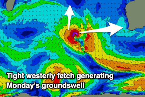 This should produce a good spike of groundswell Monday, building to 6ft+ by mid-morning if not that size at dawn across Margs, 2-3ft in Mandurah and 2ft+ in Perth.
Winds will deteriorate though as we see the remnants of the low moving in from the west, bringing freshening NE tending N/NW winds, W/NW into the late afternoon/evening. With this protected northern corners will be best.
From Tuesday the surf will be poor as we fall under onshore W/SW winds in the wake of the remnants of the low as another forms directly off our region.
This will likely see winds ease for a period during the day Tuesday before strengthening out of the W again on Wednesday.
Swell wise, there'll be a mix of easing W'ly groundswell and weak mid-period SW swell on Tuesday while the low should bring a some weak though sizey mid-period S/SW swell Wednesday. With the low projecting up into the central west large surf is due up that way but Perth and Mandurah look to come in at 2-3ft, with Margs looking to be a junky 6ft+ or so.
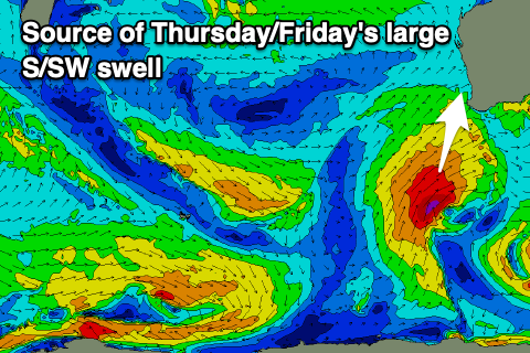 Larger surf with a bit more power and quality is expected into the end of the week as a strong polar front projects up and towards us through the middle of the week, stalling slightly while generating a fetch of gales, sometimes a little stronger at times.
A mix of mid-period and groundswell are due from the S/SW, building Thursday afternoon but peaking Friday to the 10ft range in the South West (odd bigger set) 3ft to occasionally 4ft in Mandurah and 3ft across Perth.
Due to the slow movement of the low, winds will unfortunately remain strong from the SW tending S/SW Thursday, and then W/SW on Friday in Margs. Perth and Mandurah should see lighter NE winds Friday morning with possibly lighter winds developing in the South West next weekend.
This will be as the S/SW energy eases from a moderate to large size.
Longer term the models diverge regarding possibly back up storms firing up in the Southern Ocean, so check back here on Monday for a cleared idea on the developments into May. Have a great weekend!