Fun end to the week across the swell magnets

Western Australia Surf Forecast by Craig Brokensha (issued Wednesday April 18th)
Best Days: Today, tomorrow in the South West (Perth and Mandurah beginners), Saturday late morning on the South West magnets, Monday morning
Features of the Forecast (tl;dr)
- Easing mid-period SW swell tomorrow with a reinforcing S/SW groundswell for the South West in the AM
- Gusty E/SE tending weaker SE winds
- Smaller fading surf Fri with strong E tending variable winds
- Inconsistent, small SW groundswell Sat with strong E/NE tending variable winds
- Easing SW groundswell Sun with strong E/NE tending lighter N winds
- Moderate sized + W groundswell Mon with moderate NE tending W/NW winds
- Easing surf Tue with strong W/SW-SW winds
- Large mid-period S/SW swell Wed with easing onshore winds
Recap
Fun, small surf across Perth and Mandurah yesterday to 2ft, clean again today but back to 1-2ft. Margs saw good, improving 4-6ft surf yesterday with some new mid-period SW swell, holding a similar size today with cleaner conditions. Conditions should remain favourable until early afternoon ahead of a freshening S/SE breeze.

Decent sets early this morning
This week and weekend (Apr 19 - 24)
Tomorrow will be the pick of the rest of the week and across the South West as we see the mid-period energy fading from 1-1.5ft across Perth and Mandurah, while a new pulse of S/SW groundswell fills in down south.
The source of this swell was a strong polar low forming late in our swell window earlier this week and it should keep the South West south magnets up around 4-5ft+ in the morning, easing into the afternoon and then down from 3ft max on the sets Friday.
Conditions will be clean but a bit windy tomorrow morning with a gusty E/SE offshore wind, easing and tending SE into the mid-afternoon before strengthening later into the early evening.
Strong E tending variable E winds are due on Friday with the swell magnets the pick for the keen.
 As touched on in Monday's notes, the large, slow moving high responsible for our offshore winds will block our main swell windows through the end of the week, resulting in the swell reaching a low point into the weekend in Perth and Mandurah.
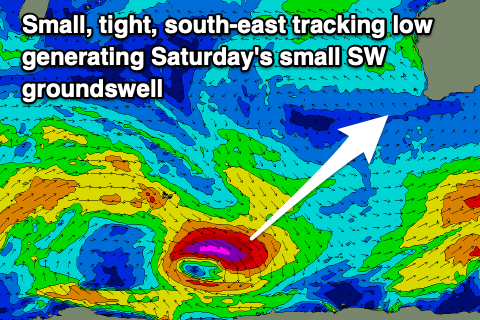
There'll be a small, inconsistent SW groundswell in the water Saturday across the South West, generated by a tight, south-east tracking polar low that's currently south-east of the Heard Island region.
This should provide inconsistent 3-4ft sets during the day on the swell magnets along with strong E/NE winds, easing into the afternoon and likely going variable. Come Sunday the swell will be on the way out, easing from 2-3ft max with strong E/NE tending lighter N winds. Not great for the start of the Margaret River Pro.
Now, as also touched on in Monday's update and the early Margaret River Pro forecast, we'll see a trough deepen into a strong mid-latitude low, west of us on Friday. The bulk of the swell generating fetch will be aimed north, into the Indian Ocean, but a tight, slim fetch of W'ly gales should be generated on its northern flank, in our western swell window, generating a moderate sized W'ly groundswell for Monday.
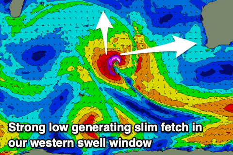 Margs looks to come in at 6ft+ with Mandurah looking at 2ft to nearly 3ft sets, 2ft+ in Perth.
Unfortunately the weakening low will move in during early next week, bringing moderate NE tending W/NW winds, strengthening into the evening.
Poor conditions are then expected in the wake of the trough with strong W/SW-SW breezes and easing surf Tuesday. Some weaker mid-period SW swell is likely from the backside of the low while we'll see a larger mid-period S/SW swell developing Wednesday as a cold front feeds into the trough, restrengthening it on Tuesday.
This should produce 6-8ft surf across the South West on Wednesday with 2-3ft waves in Perth and Mandurah but with persistent onshore winds. The models diverge on the timing of a secondary mid-latitude front moving in from the west on Thursday and we may see winds tend more variable through the day Wednesday if we're lucky, but we'll take a closer look at this on Friday.
Unfortunately the continued frontal activity will bring persistent onshore winds into the end of the week, but with some localised, mid-period swell. This isn't ideal at all for the Margaret River Pro. More on all of this Friday.
Comments
Be happy with that https://i.imgur.com/OFfF31Q.mp4