Windy week with a good swell

Western Australia Surf Forecast by Craig Brokensha (issued Monday March 28th)
Best Days: Selected breaks in the South West tomorrow, South West/Perth/Mandurah Wednesday and the South West Thursday
Features of the Forecast (tl;dr)
- Small, background SW swell tomorrow with strong E/SE winds
- Mod-large S/SW groundswell for Wed AM, easing into the PM and half the size Thu AM
- Strong E tending lighter winds Wed, strong E/NE tending variable Thu
- Moderate sized, mid-period W/SW swell building Sun with strong NE tending N winds, easing Mon with N tending NW winds
Recap
Small surf to start off the weekend with the somewhat flukey pulse of mid-period SW swell being just that. 2-3ft waves were reported in the South West with a slight increase for the afternoon, easing from a bumpy 3-4ft yesterday morning.
Perth and Mandurah were tiny on Saturday with a minimal increase in NW swell energy on Sunday, biggest through the afternoon but only to 2ft or so.
This morning the swell is back to the small to tiny stuff.
This week and weekend (Mar 29 – Apr 3)
Some fresh background SW swell is due across the South West this afternoon and tomorrow with sets to 4ft likely on the swell magnets, tiny to flat in Perth and Mandurah. This will be ahead of a stronger S/SW groundswell Wednesday, but looking at the local winds, a strong E/SE breeze is due tomorrow, holding all day.
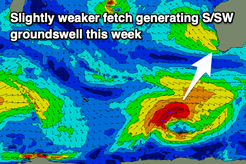 Similar winds are due Wednesday but with winds tending variable into the afternoon. Swell wise the source of our new S/SW groundswell was a strong polar low that formed south-east of the Heard Island region on Saturday evening. This low formed a touch later then forecast, and as a result a little later in our southern swell window resulting in a slight downgrade in the expected size.
We still saw a healthy fetch of gale to severe-gale W/SW winds produced with good 6-8ft sets due on the South West magnets Wednesday morning, though only 2ft in Mandurah and 1-2ft across Perth.
With those favourable winds there should be plenty of fun options, though biggest through the morning.
The swell will ease steadily into the afternoon and Thursday owing to the low moving out of our swell window quickly, bringing a dropping swell from half the size. Exposed breaks will be 3-4ft max in the South West, tiny to the north and with strong E/NE tending variable winds again.
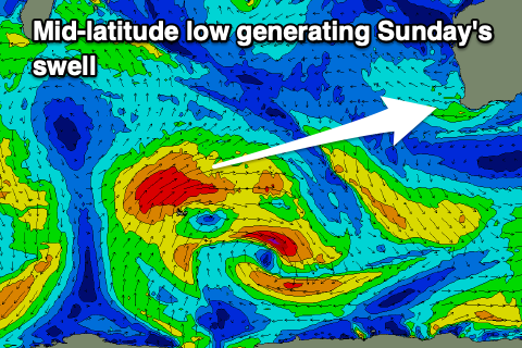
The swell looks to bottom out into the end of the week and Saturday with some new, moderate sized mid-period W/SW swell due into Sunday and Monday.
The source of this will be a relatively weak but slow moving mid-latitude low firing up north of the Heard Island mid-late week, generating a fetch of strong W/SW winds. This low will break down and push east as a trough before possibly re-intensifying directly off our coast on the weekend.
 This would bring some additional swell to the mix but we'll review this over the coming updates.
Size wise, the low alone should generate 4-6ft of W/SW swell for the South West, 2ft waves in Perth and Mandurah into Sunday afternoon, easing Monday.
Winds will deteriorate on the weekend though as the trough approaches with Sunday seeing strong NE tending N winds, then N tending NW on Monday with W'ly winds Tuesday in the wake of the trough/low.
Longer term there's more mid-period swell energy on the cards, but more on this Wednesday and Friday.