Windy period with tricky swell sources

Western Australia Surf Forecast by Craig Brokensha (issued Wednesday March 23rd)
Best Days: Later tomorrow in the South West, Friday in the South West once winds ease, Saturday and Sunday protected spots in the South West
Features of the Forecast (tl;dr)
- Smaller tomorrow morning with gusty E/SE tending E and then variable winds
- Inconsistent SW swell building into the PM, peaking Fri with gusty E/NE tending variable winds
- Inconsistent and slightly stronger SW swell building Sat, easing slowly Sun with variable offshore winds Sat, strong SE tending E/SE Sun
- No major swell from ex-Tropical Cyclone Charlotte
- Offshore winds and a moderate sized SW groundswell for mid-next week
Recap
Monday's strong pulse of SW groundswell into the afternoon held well into yesterday morning with offshore winds and 6ft+ sets across the South West, 2ft in Mandurah and Perth.
The swell abated steadily into the afternoon with smaller 3-4ft waves left across the South West this morning but with great conditions. Perth and Mandurah were also clean but 1-1.5ft.
This week and weekend (Mar 24 - 27)
Smaller surf is due tomorrow morning ahead of a small lift in mid-period energy into the afternoon, peaking through Friday.
The source of this swell was a polar, patchy fetch of strong W/NW winds with inconsistent 3-4ft sets due across the South West on Friday, tiny in Perth and Mandurah.
Winds will be favourable and gusty E/SE tending E tomorrow, variable into the late afternoon and evening with gusty E/NE tending variable winds on Friday.
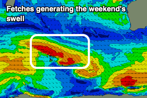 Our stronger pulse of mid-period SW swell for the weekend has been downgraded a little with the patchy fetch of stronger W/NW gales now looking slim in nature.
This will limit the size expected from this frontal system with slow sets due to build to 4-5ft through Saturday, easing from 3-5ft on Sunday.
Winds will be tricky as ex-Tropical Cyclone Charlotte moves down from the north-northwest, bringing variable N/NE tending SE winds through the day, stronger into the afternoon from the S/SE on Saturday. Sunday will then see strong SE winds, possibly tending more E/SE later in the day but this all revolves around Charlotte.
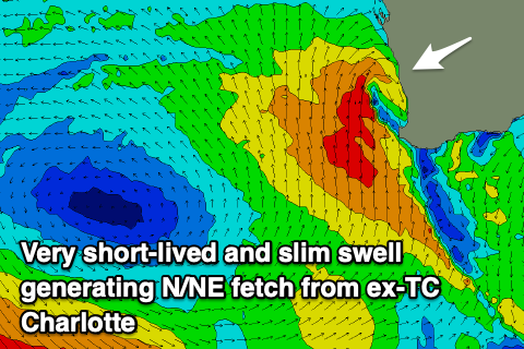 Now, looking at the swell potential from Ex-TC Charlotte and it's actually very minimal if anything.
With no supporting high pressure ridge on Charlottes eastern flank, there'll be no favourably aimed fetch of N/NW winds with any strength generated over the coming days.
It is expected to track back to the south-east through the weekend, and GFS has a brief burst of strong NW winds off the Mid West region Saturday afternoon but EC is further offshore and weaker.
In any case no major size is expected with any swell due to peak overnight Saturday and be gone on Sunday. We'll have one final look at this on Friday though.
The remnants of ex-TC Charlotte is expected to be absorbed into the eastern flank of a strong high edging in from the west Sunday possibly bringing some small S'ly swell which will fade through Monday. Again check back Friday for a clearer idea on this.
Winds should swing back around to the E through the middle of next week as the high slides under us and we could see a moderate sized SW groundswell in the mix. All these possibilities surround the movement of Ex-TC Charlotte so we'll have to review them on Friday.