Good swell this afternoon, easing

Western Australia Surf Forecast by Craig Brokensha (issued Monday March 21st)
Best Days: This afternoon protected spots, tomorrow morning, Wednesday morning in the South West, similar Thursday but more so late morning
Features of the Forecast (tl;dr)
- Moderate sized + SW groundswell building this afternoon, easing tomorrow with fresh SE tending strong S/SE winds
- Smaller swell easing Wed with E/SE tending S/SE winds, smaller again Thursday morning with strong E/SE tending S/SE winds
- New, inconsistent mid-period SW swell building later Thu, peaking Fri with strong E/NE tending variable NW winds
- Inconsistent mid-period SW swell building later Sat, peaking Sun AM with fresh S-S/SW winds Sat and strong S/SE winds Sun
- Easing SW swell Mon with strong E/SE-SE tending S/SE winds
Recap
A good kick in reinforcing SW groundswell to 5-6ft across the South West on Saturday but only clean in protected spots with a fresh S'ly wind that swung more offshore during the day and into the evening, creating improving conditions. Mandurah was 2ft and Perth 1-2ft with decent conditions.
The swell eased slowly through yesterday with clean conditions through the morning though Mandurah and Perth continued to offer similar sized waves to Saturday along with cleaner conditions.
Today a trough has brought less favourable winds along with a building SW groundswell which at the time of writing was pushing 4-5ft across the South West.
This swell should reach 6ft+ across the South West and maintain 2ft waves in Mandurah with 1-2ft sets across Perth.
This week and weekend (Mar 22 - 27)
This afternoon's pulse of SW groundswell was generated by a poorly structured but strong low over the weekend, and it's due to peak this evening, easing back through tomorrow as winds improve and swing to the SE through the morning. They'll be fresh but there should be lots of fun options with easing sets from a similar 6ft+ across the South West, 2ft in Mandurah and 1-2ft across Perth.
Wednesday will be smaller but cleaner under an E/SE offshore, tending strong S/SE into the afternoon. Hit the South West magnets.
A temporary low point is due Thursday morning but with offshore E/SE winds again ahead of some new mid-period SW swell later in the day but more so Friday.
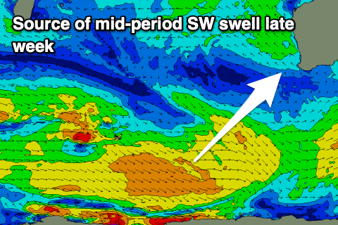 The source of this swell and further pulses into the weekend and next week will be relatively weak but persistent polar fronts pushing east along the polar shelf.
Patchy fetches of mostly strong W/NW winds with some gale-force bursts are expected and this will keep the size below that 6ft range in the South West and under 1-2ft in Perth and Mandurah.
Under this setup though we'll see a high sitting just south-east of us, bringing generally favourable offshore morning winds, strong and out of the E/SE on Thursday, shifting more E/NE on Friday morning, with a trough bringing a weak S/SW change on Saturday. A new high will move in on Sunday bringing strong S/SE winds, tending SE late in the day and then E/SE-SE Monday morning and then remaining E/NE-NE for the rest of next week.
 Back to the swells though and later Thursday's increase is minimal with Friday only likely to come in at 3-4ft, tiny in Perth and Mandurah.
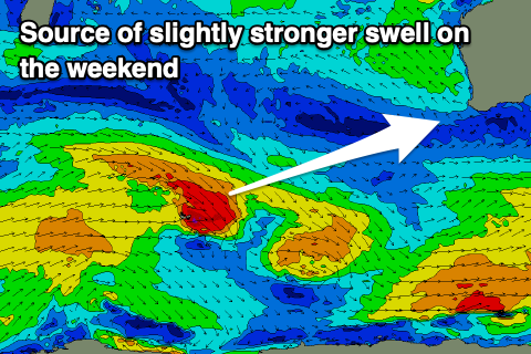
Saturday morning looks to come in at a similar size with some slightly better and longer period (still mid-period) swell due to arrive into the afternoon and peak Sunday morning. This will be generated by the embedded gales within the progression and should provide 4-5ft sets across the South West magnets, 1-1.5ft waves in Mandurah with 1ft surf in Perth.
The size is due to ease slowly Monday with those improving winds, smaller Tuesday but cleaner. Longer term there's still nothing too major on the cards swell wise so make the most of the windows in the South West and Perth/Mandurah over the coming days.
Comments
Good set just rolled through..
Hey Craig, Any thoughts on what TC Charlotte might throw up? Cheers
Ah sorry missed that. Nothing unfortunately, hence missing it.
It's got no favourable N/NW swell generating fetch until it pushes into Carnarvon/Geraldton (EC solution) so just a stormy, local windswell up that way.
Will keep an eye on it for changes.
If you see any changes don't tell anyone...deal
Let's go old school and let them work it out for themselves
had a check of the Kalbarri cam with this cyclonebut it's a past history shot - maybe from just before Seroja?
https://www.abc.net.au/news/2022-03-21/multiple-fatalities-after-boating...
It looks ideal in certain locations.