Fun swells to continue with a bit more wind

Western Australia Surf Forecast by Craig Brokensha (issued Friday March 18th)
Best Days: Now before winds increase from the west, protected spots tomorrow, exposed spots later, Sunday morning, Monday protected spots, Tuesday morning, Wednesday morning in the South West
Features of the Forecast (tl;dr)
- Reinforcing SW groundswell for tomorrow with strong S/SE tending SE winds
- Easing SW swell Sun with moderate SE tending strong S/SW winds
- Building SW groundswell Mon with strong S/SE winds, easing Tue with fresh SE-E/SE tending strong S/SE winds
- Smaller into Wed with E/SE morning winds
Recap
The new swell expected through yesterday filled in a touch ahead of schedule according to my calculations but with light winds and clean conditions across Perth and Mandurah, no one was complaining. Sets to 2ft+ were seen and Margs was 6ft+, building to 6-8ft through the day though a bit bumpy.
Today the swell was still strong but easing with 6-8ft sets in the South West under a variable breeze, 2-3ft in Mandurah and 2ft+ across Perth. Winds have been variable all morning but are just starting to swing more onshore (but very light) and will freshen this afternoon out of the west.
This weekend and next week (Mar 19 - 25)
This afternoon's change is linked to a surface trough slipping in from the west and this will continue east tomorrow morning with winds strengthening but shifting back to the S/SE early, tending SE for periods in the morning and settling in through the afternoon.
 Swell wise, we've got a reinforcing pulse of SW groundswell due tomorrow, generated by a poorly structured but strong low moving in behind the frontal progression linked to the current swell.
4-6ft waves are expected across the South West though the magnets will likely be more 5-6ft with Perth and Mandurah coming in at 2ft and 1-2ft respectively. With the improving winds the afternoon and evening will be cleanest but the swell will likely be starting to ease by then.
Winds should relax into Sunday and continue out of the SE (possibly tending E/SE at periods) ahead of strong S/SW sea breezes. The swell will be easing so get in through the morning for the best waves.
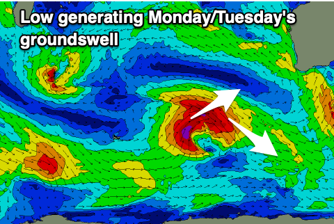
Monday will start slightly smaller again but a new SW groundswell is due to arrive through the morning, building towards a peak through the afternoon to 6ft+ in the South West. This swell will be generated by a small tight low pushing up towards us on the weekend, generating pre-frontal W/NW gales and post-frontal SW gales.
It's not ideal but fun waves are expected, with Mandurah coming in at 2ft with 1-2ft sets in Perth.
Winds look tricky on Monday and strong from the S/SE, favouring protected spots, with Tuesday improving as winds shift SE-E/SE as the swell eases from a similar size to Monday afternoon and evening.
Following this there's nothing too significant on the cards for the rest of the week but we may see a good new SW groundswell for next weekend. More on this Monday. Have a great weekend!
Comments
Mandurah wasn’t quite 2-3 foot today .. noticeably smaller than yesterday, a slow weak 2 foot at best at the magnets with many people just not bothering!