Average outlook with more action mid-late next week

Western Australian Surf Forecast by Craig Brokensha (issued Friday March 11th)
Best Days: Keen surfers on the South West swell magnets tomorrow morning and Sunday morning, Thursday morning all locations
Features of the Forecast (tl;dr)
- Small pulse of S/SW groundswell tomorrow with N/NE tending W/NW winds, easing Sun with variable winds in the South West
- Developing onshore winds and tiny early next week
- Large, building SW groundswell later Wed, peaking Thu with variable tending W/SW winds
Recap
Nothing to surf in Perth or Mandurah with small, background levels of swell for the South West to 2ft to occasionally 3ft yesterday, a touch slower today. Conditions have been best late morning to early afternoon with easing offshore winds.
This weekend and next week (Feb 12 - 18)
Unfortunately the majority of the coming period looks void of any decent surf, with high pressure being dominant the past week or so, suppressing any significant Southern Ocean frontal activity.
A trough will linger off our region on the weekend, bringing N/NE winds tomorrow morning before shifting W/NW into the afternoon and freshening. These winds will persist across Perth and Mandurah on Sunday but the South West should see variable winds as the axis of the system sits just north of the region.
Swell wise, a small pulse of S/SW groundswell is due across the South West, generated by a strengthening polar low late in our swell window yesterday. A brief fetch of W/SW gales were generated and this should produce a little lift in swell for the south magnets tomorrow to 3ft to possibly 4ft with those favourable N/NE winds. Sunday will see the swell easing from 3ft on the sets with the variable breezes.
Into early next week the swell will reach a low point as the trough will finally push east bringing developing SW winds on Monday, strengthening from the W on Tuesday as a mid-latitude front approaches from the west.
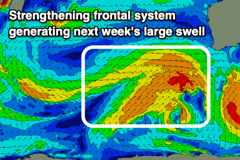 This mid-latitude front is expected to deepen and possibly form into a low on approach to us, with a great fetch of gale to severe-gale W/SW winds forecast to be generated south-west of us on Wednesday.
A large SW groundswell is expected, with it possibly being upgraded if it does develop into a low, but regardless we should see building surf Wednesday afternoon, peaking Thursday to 6-8ft in the South West, 2-3ft in Mandurah and 2ft in Perth. Winds will be average still on Wednesday as the front pushes through, with Thursday possibly seeing variable morning winds as the front clears east.
A secondary trailing front may generate some additional swell on Saturday but winds look dicey at this early stage. More on this Monday. Have a great weekend!