Nothing of note until later next week

Western Australia Surf Forecast by Craig Brokensha (issued Wednesday March 9th)
Best Days: Swell magnets in the South West Saturday morning, late next week
Features of the Forecast (tl;dr)
- Small levels of weak backgroundswell Thu and Fri with light-mod E/SE tending E/NE winds ahead of weak sea breezes
- Small S/SW groundswell Sat with N/NE tending mod-fresh N/NW and then W/NW winds
- W/SW winds Sun
- Mod-large W/SW groundswell Thu with fresh S/SW winds
- Larger SW groundswell building Fri, easing Sat with E/SE winds Fri AM and SE winds Sat AM
Recap
Windy but good surf yesterday, best late morning as offshore winds eased and with 4-5ft sets on the magnets. Today the swell is on the ease and winds were strong again but abating.
This week and weekend (Mar 10 - 18)
Down, down, down.
The current swell will continue to ease into tomorrow, and besides a weak, mid-period reinforcing S/SW swell Friday there's no increase in size expected.
Tomorrow looks to be back to 2ft, with the odd possible 3ft set for the patient on the magnets, similar Friday morning, then easing into the afternoon.
 Conditions will be clean and good for the magnets with a light to moderate E/SE tending E/NE breeze ahead of relatively weak sea breezes, similar Friday.
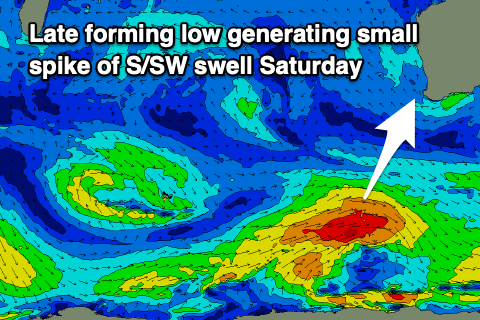
Come Saturday a new pulse of S/SW swell is due, generated by a late forming polar low in our swell window tomorrow. A fetch of W/SW gales should produce a fun kick to 3ft+ across the South West though winds are funky as a trough sits east of us, with light N/NE breezes due, shifting N/NW through the day and W'ly into the afternoon. Try the south magnets through the morning.
Lingering W/SW winds are due through Sunday with a drop in S/SW swell making it a lay day.
The surf will remain small and onshore into early-mid next week but from Thursday we should see building surf owing to a strengthening Southern Ocean polar frontal progression west and south-west of us.
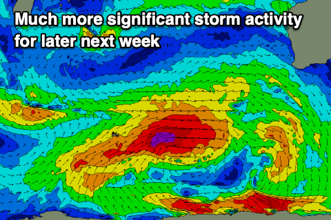 An initial mid-latitude low/front should bring a building W/SW groundswell on Thursday, followed by a larger SW groundswell Friday afternoon and Saturday morning from a broader, stronger polar low.
Winds unfortunately look strong from the S/SW on Thursday in the wake of a front Wednesday, shifting E/SE into Friday if all goes to plan, SE on Saturday.
Size wise at this stage Thursday's swell looks to be 6ft to occasionally 8ft in the South West, 2ft+ in Mandurah and 1-2ft across Perth with the larger swell to 10ft+ in the South West. More on this Friday.