Fun run of surf this period

Western Australia Surf Forecast by Craig Brokensha (issued Wednesday March 2nd)
Best Days: Margaret River every morning this period (protected spots tomorrow morning)
Features of the Forecast (tl;dr)
- Easing SW swell tomorrow with moderate S/SE (SE Perth and Mandurah) tending strong S/SW winds
- Building mid-period SW swell Fri PM with moderate E/SE tending fresh S/SW winds
- Larger SW groundswell Sat with fresh E/SE tending S/SW winds, easing Sun with mod-fresh E/NE tending S/SW winds
- Smaller Mon AM with strong E/SE-SE tending S/SW winds
- New, mid-period SW swell Tue with E/SE tending S/SW winds
Recap
Building surf and workable winds early across the South West yesterday morning but deteriorating into the afternoon as the swell become stronger and larger. Perth and Mandurah were tiny and poor with this morning offer a bit more surf to the 2ft range but with bumpy/lumpy conditions. The South West was still choppy and best in protected spots.
This week and next (Mar 3 - 11)
The current swell will ease this afternoon and further tomorrow as winds ease and tend more S/SE across the South West with SE winds in Perth and Mandurah. It'll be tiny to the north though with easing sets from 4-5ft across the South West, best in semi-protected spots.
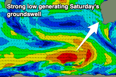 A temporary low point in swell is due early Friday but into the afternoon, the first of a series of SW swells are due, initially mid-period with a SW groundswell for Saturday.
The source of these swells is patchy polar frontal activity occurring around the Heard Island region, with the strongest fetch of W/SW winds now just east of the area.
There's been a slight upgrade in size due on Saturday, with Friday due to build from 3-4ft to 4-5ft into the afternoon with Saturday coming in at 5-6ft on the sets. Unfortunately Mandurah won't see any real size with tiny 1-1.5ft waves due on Saturday, tiny in Perth.
Conditions look much better on Friday with a moderate E/SE offshore wind ahead of strong S/SW sea breezes. Saturday will see fresher E/SE offshore winds in the morning ahead of stronger sea breezes while Sunday also looks great with moderate to fresh E/NE offshore ahead of later sea breezes and easing levels of swell.
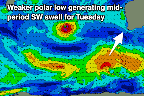 Looking into next week and some small, reinforcing mid-period SW swell is due into late Monday and Tuesday, generated by a weaker polar low firing up to our south-west on the weekend. At this stage it looks to generate 4-5ft of SW swell for Margs as favourable morning offshore winds persist, but Perth and Mandurah will continue to miss out.
Longer term, there's still nothing major on the cards for the end of next week/weekend and beyond but more on this Friday.
Comments
Gday Craig I don’t suppose and you have probably been asked a thousand times the camera for margs is up and running
Cheers Greg