Small swells with south to south-east winds

Western Australia Surf Forecast by Craig Brokensha (issued Monday February 21st)
Best Days: Friday morning in the South West for the keen, Monday, Tuesday and Wednesday mornings next week in the South West
Features of the Forecast (tl;dr)
- Small, weak mid-period S/SW swell tomorrow with moderate S/SE tending strong S-S/SW winds
- Small, fleeting pulse of SW swell Wed PM with strong SE tending stronger S/SE winds
- Inconsistent, mid-period SW swell building Thu PM, peaking Fri with strong SE tending S/SE winds
- Easing swell Sat with S/SE tending S winds, smaller Sun with fresh SE tending S/SE winds
- Inconsistent, moderate sized SW groundswell Mon, with a stronger pulse Wed with S/SE-SE morning winds
Recap
Early light winds with a good pulse of new S/SW groundswell Satueday to 5-6ft across the South West but only 1-1.5ft in Mandurah and tiny across Perth. Conditions deteriorated through the day as a trough brought a change, with Sunday being best in the South West with a dropping swell from 4ft but with more favourable winds.
Today conditions are great in the South West but the swell small, weak and fading. It's on the way out.
This week and weekend (Feb 22 - 27)
Tomorrow will be another lay day across the state with less favourable winds and a small swell that's not worth really bothering about under a moderate S/SE tending strong S-S/SW breeze.
 A weak low that's currently moving past our south-west corner is generating a poorly aimed fetch of NW gales and weaker, trailing SW winds, with no major swell or size due off this into Wednesday afternoon. The South West magnets may see small surf to 3ft+ at best, tiny in Perth and Mandurah.
Winds should improve a touch but be strong on Wednesday and from the SE, stronger from the S/SE into the afternoon.
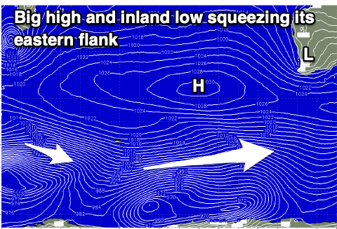
A similar pattern in winds is due Thursday and Friday as a deepening inland surface trough squeezes a strong high south-west of us, and this will effectively put a block on our main swell windows.
Some small, inconsistent mid-period SW swell is due into Thursday afternoon and more so Friday, generated by broad but relatively weak polar frontal activity. Unfortunately without any gale-force fetch embedded in the progression, we can't expect much over 3ft+ Thursday afternoon in the South West with 3ft to occasionally 4ft sets Friday on the magnets. Perth and Mandurah will remain tiny.
 Those strong SE winds will also create tricky conditions with the weekend looking a bit suss with winds due to revert back to the S/SE Saturday morning, then back to the SE on Sunday.
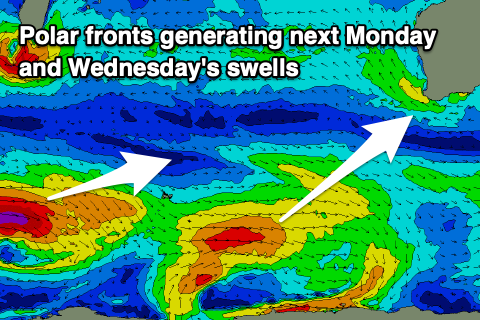
There's a bit more size due into next week as a slightly better frontal progression sets up along the polar shelf later this week. Fetches of strong to gale-force W'ly winds should produce moderate pulses of swell, the first for Monday and the best for Wednesday. At this stage sets to 5-6ft are due Wednesday with the peak in swell but with persistent S/SE-SE morning winds, limiting options. More on this Wednesday though.
Comments
Hiya ,
Is there any chance of getting some more comments on Mandurah,Perth to give us hope :) we all generally know South West is best but for us wave starved Perth surfers be nice to be given a little more to look forward to on this flat summer .
I think he would of told us if anything was on the horizon for us, unfortunately this has been the worst summer surf wise I can recall for the Rockingham stretch ie Secrets , but its still not stopping droves of people rocking up every weekend
Yeah unfortunately there isn't much to talk about for those regions otherwise I would point them out.