Good run of surf for the state

Western Australia Surf Forecast by Craig Brokensha (issued Monday February 14th)
Best Days: Margs tomorrow morning, Thursday morning all locations, Friday all locations, Saturday morning protected locations, Sunday morning in the South West
Features of the Forecast (tl;dr)
- Reinforcing mid-period SW swell tomorrow with fresh E/SE winds ahead of sea breezes
- Smaller Wed with S/SE tending S/SW winds
- Mod-large SW groundswell Thu with mod-fresh E/SE tending strong S/SW winds
- Easing SW groundswell Fri with fresh E/NE tending lighter W/NW-NW winds
- Reinforcing SW groundswell Sat with S/SE tending S/SW winds
- Easing SW groundswell Sun with fresh SE tending stronger S/SE winds
Recap
Average surf to kick off the weekend with lumpy/bumpy waves and a drop in size from Friday but Sunday saw a larger, building W/SW swell with great conditions and 6ft+ waves across the South West, reaching 6-8ft into the afternoon. Mandurah was 2ft, reaching 2-3ft with Perth building to 2ft+ but with sea breezes.
This morning the swell has eased a touch but is nice and clean with fun options across most regions.
This week and weekend (Jan 15 - 20)
The current easing W/SW swell will be slowed by a reinforcing pulse of mid-period swell from the SW tomorrow, keeping 3-5ft sets hitting the South West magnets, tiny in Perth and Mandurah. This swell was generated by a weaker front moving in behind the front linked to the current swell and conditions look great with a fresh E/SE breeze in the morning ahead of afternoon sea breezes.
 Wednesday still looks like a lay day as a trough brings a shift in winds back to the S/SE as we fall in betweens swells.
The next increase in size is due later Wednesday but more so Thursday, that being a moderate to large SW groundswell. The source of this swell is a strong polar low that’s developed just east of the Heard Island region with a great fetch of severe-gale W-W/NW winds being projected slowly east through our south-western swell window, moving more into our southern swell window tomorrow afternoon and evening.
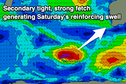
A secondary strong follow up front will race in on the back of the low Wednesday generating an additional fetch of W/NW gales and reinforcing pulse of S/SW groundswell for Saturday.
Size wise, the first pulse on Thursday should come in at 8ft on the sets across the South West, 2ft to occasionally 3ft in Mandurah and 2ft on the sets across Perth along with moderate to fresh E/SE winds in the morning and strong sea breezes.
 The swell looks to drop back slightly Friday with great E/NE winds in the morning ahead of weak sea breezes with the reinforcing swell Saturday due to boost wave heights back to 6ft+ across the South West, 2ft in Mandurah and 1-2ft in Perth. Conditions look a little less favourable with a trough bringing a shift in winds back to the S/SE with fresh SE winds Sunday morning.
Longer term there’s nothing too major on the cards with tropical activity in the Indian Ocean taking up most of our swell window so get stuck into the coming swells.
Comments
Yesterday..