Good run of surf coming for the South West

Western Australia Surf Forecast by Craig Brokensha (issued Friday February 11th)
Best Days: Tomorrow morning in the South West, Sunday morning, Monday morning, Tuesday morning in the South West, Thursday and Friday mornings next week
Features of the Forecast (tl;dr)
- Easing SW swell tomorrow with early variable tending strong S/SW winds mid-morning in the South West, S/SW tending S/SE then S/SW to the north
- New mid-period W/SW swell building later tomorrow, peaking Sun PM with mod-fresh E/SE-SE tending stronger S winds
- Easing mix of swells Mon with mod-fresh SE tending S/SE winds (E/NE in Perth and Mandurah)
- Reinforcing W/SW swell Tue with E/NE winds ahead of sea breezes
- Moderate sized + SW groundswell building Thu, holding Fri with morning offshore winds
Recap
Clean conditions with a slow increase in inconsistent SW groundswell yesterday, building from the 4ft range across the South West before sea breezes kicked in, tiny to the north with the swell arriving later.
Today the peak of the swell has filled in with early light winds across the South West with 5-6ft sets, 1-2ft waves in Mandurah while Perth was unfortunately tiny. Winds have since swung onshore across all locations.

Clean early

Bumpy now
This weekend and next week (Jan 12 - 18)
Today's developing onshore winds are linked to a weak trough moving in from the west and it'll leave average S/SW tending S/SE winds across Perth and Mandurah tomorrow morning with the Margaret River region likely to see early variable winds before kicking in strong from the S/SW mid-morning.
 Today's swell will be on the ease with 4-5ft+ waves in the South West, 1ft to nearly 2ft waves in Mandurah and tiny surf across Perth.
Later in the day some new mid-period W/SW swell is due, peaking through Sunday across the state.
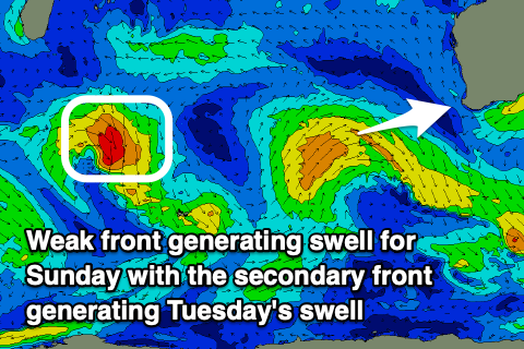
The source of this swell is a relatively weak but favourably tracking mid-latitude front currently pushing up and in from the west. A fetch of strong W/SW winds are being generated, while there'll also be some inconsistent SW groundswell from the earlier stages of the front in the mid Sunday.
The South West should peak Sunday afternoon with sets to 6ft to occasionally 8ft across the South West, though only mid-period in nature, 2ft to occasionally 3ft in Mandurah and 2ft+ in Perth.
The swell will ease through Monday from a slightly smaller size range but conditions looks best Sunday. A moderate to fresh E/SE-SE wind is due ahead of strong sea breezes, with Monday seeing moderate to fresh SE tending S/SE winds across the South West and E/NE tending S/SW winds in Perth and Mandurah.
We should see a small, reinforcing pulse of mid-period W/SW swell on Tuesday, generated by a weak pre-frontal fetch of W/NW winds pushing in from the west behind the weak front generating Sunday's swell. This will maintain 4-5ft sets in the South West with 1-1.5ft waves in Mandurah and tiny surf across Perth.
 Conditions will be great across all locations with a moderate E/NE breeze ahead of weak sea breezes.
A trough will bring average S/SE winds as the swell drops into Wednesday.
Longer term we've got some healthy but not overly strong or consolidated polar low and frontal activity firing up on the weekend and into early next week will generate building levels of SW groundswell into Thursday and Friday. At this stage it looks to be around a great 6-8ft in the South West and with great winds. More on this Monday. Have a great weekend!