Improving surf later week

Western Australia Surf Forecast by Craig Brokensha (issued Monday February 7th)
Best Days: Tuesday morning Perth and Mandurah (keen surfers in the South West), Thursday morning, Friday and Saturday morning protected spots, Sunday morning in the South West
Features of the Forecast (tl;dr)
- Weak, easing SW swell tomorrow with lingering SW winds in the South West, E/SE to the north
- Inconsistent SW groundswell building Thu with fresh E/SE-SE tending S/SW winds, peaking Fri with S/SE tending S/SW winds
- Easing SW swell Sat with S/SE tending S/SW winds
- Reinforcing SW swell Sun with E/SE tending SW winds
Recap
Friday’s underperforming swell was replaced by a weaker, mid-period reinforcing pulse on Saturday to 3-4ft in the South West with early light winds, deteriorating through the day. Yesterday was poor with smaller surf and average conditions.
Today a developing low off our South Coast is continuing to bring poor conditions and strong SW winds, but the swell off this low has been downgraded further. This is discussed in more detail below.
This week and weekend (Feb 8 - 13)
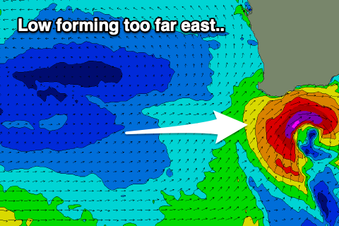 As the forecast has evolved, the severe low that was forecast to form south-west of us, bringing large stormy surf to the South West is now currently forming a bit further east and out of our swell window, impacting the South Coast.
The low will reach severe-gale strength out of the Margaret River regions swell window, and as a result we’re only due to see weak levels of SW windswell during today, easing steadily tomorrow as it continues east.
Winds will ease but linger from the SW across the South West tomorrow morning with easing sets from 4-6ft, 2ft across Mandurah and 1-2ft in Perth. Conditions will be cleaner in Mandurah and Perth with a light E/SE offshore ahead of sea breezes.
 Wednesday will become smaller and weaker as winds shift to the S/SE across Margs. Surfing options will be limited though.
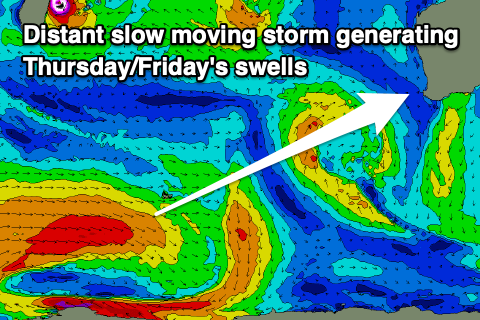
We’ve got some better, inconsistent SW groundswell due into Thursday and Friday across the state, generated by a distant but strong polar frontal progression that developed south-east of South Africa on the weekend.
A slow moving and persistent fetch of strong to gale-force W’ly winds are now weakening while pushing east across the Heard Island region, with the swell due to arrive Thursday and build to 5-6ft during the day across the South West, an infrequent 2ft on the sets into the afternoon across Mandurah and 1-2ft in Perth later. Friday should come in around a similar size across Perth and Mandurah with 5-6ft+ sets in the South West.
Winds on Thursday look favourable and E/SE-SE across the South West, clean to the north, while a trough will bring S/SE winds on Friday as the swell peaks. Saturday looks to offer similar winds as the swell starts to ease, favouring protected spots.
Into Sunday and Monday, some reinforcing, mid-period SW swell is due across the South West, generated by weaker trailing polar frontal activity behind Thursday/Friday’s swell producer.
Winds look good for Sunday and Monday mornings with 3-5ft surf in the South West on the former, fading Monday. Longer term there’s still nothing too significant on the cards but more on this Wednesday.