Deteriorating surf and winds through the weekend

Western Australia Surf Forecast by Craig Brokensha (issued Friday February 4th)
Best Days: Keen surfers selected spots in the South West tomorrow morning, Perth and Mandurah Tuesday morning, the South West Thursday and Friday mornings next week
Features of the Forecast (tl;dr)
- Inconsistent, easing SW swell tomorrow with S/SE tending S/SW winds in the South West, cleaner to the north but tiny
- Low point in swell Sun with variable tending S/SW then stronger W/SW winds
- Buildig stormy swell in the South West Mon, weaker and smaller to the north with strong SW winds
- Easing S/SW swell Tue with S/SW winds (SE further north in Mandurah and Perth)
- Moderate sized+ swell for Thu and Fri with morning E/SE winds, possibly a touch bigger next weekend with S winds
Recap
A low point in swell yesterday with clean, warm morning conditions, hotter today with a small lift in inconsistent groundswell across the South West, though under the expected 4-5ft. The swell has lifted a touch more since early but is still slow.
This week and next (Jan 5 - 11)
Today's inconsistent SW groundswell should be reinforced by a secondary, mid-period swell alter today, with no adjustment needed to tomorrow morning's size.
It'll be inconsistent but we should hopefully see 3-5ft sets on the South West magnets, tiny in Perth and Mandurah along with a less than ideal, light to moderate S/SE breeze. Perth and Mandurah should offer a better offshore wind but there'll be no size.
Smaller surf is due into Sunday and an approaching trough will bring early light winds that will shift south-southwest and then west-southwest while strengthening later in the day. This will be as the trough supports the formation of a severe low with it being strongest once moving just off the SW tip of the South West region.
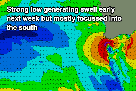 A fetch of severe-gale SW winds will be generated in our close-range swell window, kicking up a rapid, stormy increase in swell through Monday, peaking late in the day before easing rapidly from the S/SW on Tuesday.
Perth and Mandurah aren't due to see any major size as the low forms a little south but we should see building levels of SW windswell from 2ft in the morning to 3ft later in the day across Mandurah, 2ft+ in Perth. Margs should build to 8ft+ through the day but strong SW winds will create poor conditions.
As the low moves off to the east Tuesday winds will unfortunately linger from the S/SW across the South West, but shift SE in Mandurah in Perth but with easing 2ft sets max, dropping from 6ft+.
Wednesday looks a little cleaner with a S/SE breeze in the morning but small, fading swell.
Longer term, more favourable SE winds late next week look to shift S'ly on the weekend as a progression of stronger polar fronts start to fire up from the Heard Island region, squeezing the bottom flank of a high sitting to our west.
This will bring moderate sized+ pulses of swell for later next week and next weekend, coming in around 6ft or so across the South West, 2ft on the sets in Mandurah and 1-2ft across Perth but more on this Monday. Have a great weekend!
Comments
You promised 10000 ocean energies
Today was shit
Lucky if it was even 3 foot
Far from the 4-5ft forecast
Not sure how you were expecting 4-5ft when the swell is less than 1m?!
Yeah bummer, the low looked decent as well but was short-lived.
Hard to expect only a weak 3ft off this thing..
Interestingly it's not often you see Rotto kick before DS with a SW swell
Surfed an open beachie. It was slow, 3foot, but every half hour, solid 4 foot plus pulses came through. Had plenty of oomph for the size.
Some sketchy fires down this way. Hope they get it under control....massive SW blast coming. Batten down the hatches!!
Thanks BD.