Stronger swell later today, easing with less favourable winds

Western Australia Surf Forecast by Craig Brokensha (issued Friday January 28th)
Best Days: Later today in the South West, tomorrow semi-protected spots in the South West, exposed locations Perth and Mandurah, protected spots Sunday morning in the South West, Friday morning and Saturday morning next weekend
Features of the Forecast (tl;dr)
- Mod-large SW groundswell building later today, easing tomorrow with moderate S/SE tending strong S-S/SW winds (E/NE in Perth and Mandurah in the AM)
- Further drop in swell Sun with gusty S/SE winds in the AM, smaller Mon with strong S/SE winds
- Fading surf Tue with strong SE tending S/SE winds
- Inconsistent SW groundswell arriving late Thu, peaking Fri, holding Sat with morning E/NE winds and afternoon sea breezes
Recap
A lift in swell yesterday morning across the Margaret River region with decent conditions for semi-protected breaks and 3-4ft sets. Perth and Mandurah remained tiny and peaky.
Today the mid-period swell is peaking with better winds, coming in at 4-5ft on the South West magnets, still tiny to the north but 1-1.5ft in Mandurah and 1ft across Perth.


Fun surf this AM
This weekend and next week (Jan 29 – Feb 4)
Into this afternoon we should see a larger pulse of SW groundswell starting to fill in, generated by a strong polar low that fired up in our swell window during the earlier stages of the week.
The swell should kick to 6ft+ across the South West later but with strong S'ly winds, shifting back to the S/SE on dark. Try protected spots for a wave.
Come tomorrow morning the swell will be on the ease but early 6ft to occasionally 8ft sets are due in the South West with 2ft sets in Mandurah and 1-2ft waves across Perth.
Winds won't be as favourable as this morning with a moderate S/SE breeze due across the South West, better and E/NE to the north ahead of strong S-S/SW sea breezes.
Gustier S/SE winds will kick in Sunday as the swell eases further in size from 3-5ft in the South West along with tiny options to the north.
Moving into next week, the size will continue to fade and a small reinforcing S/SW swell due Tuesday now looks very weak and average with the small front linked to it now unlikely to generate much over 3ft during the morning.
Winds will unfortunately remain average as a strong high takes its time moving east, bringing strong S/SE winds on Monday morning, easing a touch and shifting SE on Tuesday morning.
Wednesday will see better E/SE winds but there'll be no swell left in the tank.
Thursday will also be clean but flat, with some new, inconsistent mid-period swell due to arrive later in the day and build further through Friday and into Saturday.
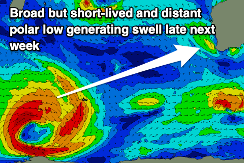 The source of these swells will be a broad polar low firing up south-east of South Africa on the weekend and while impressive on paper the fetch of W/SW gales will be short-lived and a fair distance from us.
This will produce an inconsistent swell that should arrive later Thursday but peak Friday to an inconsistent 4ft or so in the South West, tiny across Perth and Mandurah. A secondary pulse of reinforcing swell to a similar size is due on Saturday, then easing Sunday.
Winds look great as the broad, strong high pushes slowly east, directing E/NE winds across us in the mornings ahead of sea breezes. Longer term we may see a stronger polar low generating a better groundswell for the following week. More on this Monday. Have a great weekend!