Poor end to the week, a little window on the weekend

Western Australia Surf Forecast by Craig Brokensha (issued Wednesday January 12th)
Best Days: South West swell magnets Saturday morning and possibly Monday morning, Thursday-Saturday week in the South West
Features of the Forecast (tl;dr)
- Tiny tomorrow with gusty S/SE tending S/SW-SW winds
- Small, building mid-period SW swell late Fri with light S/SE tending strong S/SW winds
- Peak in mid-period SW swell Sat with E/SE winds ahead of strong SW sea breezes
- Easing mid-period SW swell Sun, with a reinforcing pulse of S/SW energy later in the day. Fresh S/SE tending S/SW winds
- Easing S/SW swell Mon with fresh SE-E/SE winds ahead of sea breezes
- Fading surf Tue with morning E/NE winds
- Building, inconsistent SW swell Thu, peaking Fri/Sat with morning E/SE winds
Recap
Strong offshore winds but no decent size across the South West yesterday with leftover 2ft sets, similar today but with less wind. Further north in Perth and Mandurah conditions were clean in the morning but the surf tiny.
This week and weekend (Jan 11 - 16)
The coming days aren't worth worrying about but we have some fun waves on the cards for the swell magnets come the weekend.
This afternoon and evening, a small surface low sitting west of us should move east and bringing gusty S/SE winds to most locations, stronger from the S/SW-SW into the afternoon but with no new swell.
Friday should see lighter S/SE winds early before shifting S/SW and strengthening along with a new, building mid-period SW swell later.
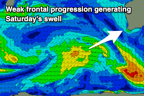 The source of this swell is a relatively weak frontal system moving in from the south-west today and tomorrow. Unfortunately the weak nature of the frontal progression will limit any major size being generated, with building surf to 3ft due later in the day across the South West magnets, peaking Saturday to 3-4ft.
Perth and Mandurah won't see any size with tiny 1ft waves due Saturday and Sunday.
Locally winds will improve on Saturday with a light E/SE offshore due across the South West (S/SE to the north) before strong SW sea breezes kick in. Unfortunately less favourable S/SE breezes are due Sunday as the swell eases from 3-4ft in the South West.
A reinforcing pulse of mid-period S/SW swell is due Sunday afternoon, generated by a small, trailing mid-latitude front that will deepen late in our swell window Saturday afternoon.
This should produce a kick in size later to 4ft+ but with afternoon sea breezes, easing from 3ft to possibly 4ft Monday morning under a fresh SE-E/SE breeze. Unfortunately Perth and Mandurah will remain tiny owing to the weak and southerly nature of the swell source.
 Smaller surf is due into Tuesday and Wednesday as winds shift E/NE and then N/NE respectively each morning.
Longer term some inconsistent mid-period SW swell is due later next week, with some small, long-range groundswell in the mix.
The source of these swells is an initial strong polar low south-east of South Africa, followed by a broader, slower moving low across the Heard Island region. Size wise we're probably only looking at waves to 4-5ft+ or so across the South West at the peak of the swell next Friday/Saturday though with offshore winds. Perth and Mandurah look tiny and to 1-1.5ft. We'll confirm this on Friday though.