Very slim pickings this period

Western Australia Surf Forecast by Craig Brokensha (issued Friday December 24th)
Best Days: Sunday ahead of sea breezes in the South West. Monday in the South West
Features of the Forecast (tl;dr)
- Low point in swell tomorrow with strong E/SE winds and sea breezes
- Building mid-period SW swell Sun with strong E/NE winds, easing and tending NE ahead of afternoon sea breezes
- Easing swell Mon with strong E/NE tending lighter N/NE winds and afternoon sea breezes in Perth and Mandurah (variable in the South West)
- Small, inconsistent mid-period SW swell building late Tue, peaking Wed with S-S/SW winds
Recap
Easing surf through yesterday but still fun and clean in the 4ft range across the South West, smaller and peakier to 1-2ft in Perth and Mandurah.
Today the surf is weak and fading with 2-3ft leftovers in Margs, tiny across Perth and Mandurah.
This weekend and next week (Dec 25 - 31)
Down, down, down.
That's the trend into the weekend as winds increase and the heat picks up.
Perth and Mandurah are due to be tiny to flat tomorrow with possibly stray 2ft sets across the Margaret River swell magnets. It'll be windy with strong E/SE winds, easing ahead of afternoon sea breezes in Perth and Mandurah, S/SE winds across Margs,
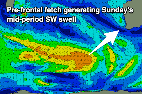 Strong but easing E/NE tending NE winds will be seen through Sunday, giving into afternoon sea breezes and we should see our new, mid-period SW swell building through the day.
The source of this was a good fetch of strong to near gale-force W/NW winds moving in north and north-east of the Heard Island region the last couple of days.
The swell is only mid-period in size but should be fun, with it building through the day to 3-5ft across the swell magnets and 1-1.5ft in Mandurah later, 1ft in Perth. With the sea breezes, the surf will be best late morning before they kick in.
Monday morning will be windy and hot again with strong E/NE offshore breezes, tending N/NE through the day and then variable in the South West with sea breezes further north. Size wise the mid-period SW swell should be easing, dropping from 3-4ft in the South West, tiny to the north.
Tuesday looks to be a lay day as the swell bottoms out along with lighter, morning offshore winds.
 The models are showing a new, mid-period SW swell for Tuesday afternoon and Wednesday morning but the source of this swell looks flukier. Pre-frontal NW winds aimed poorly in our swell window will produce a less consistent and smaller pulse of swell for Tuesday afternoon, possibly to 2-3ft in the South West but with sea breezes. Wednesday will reveal the peak but sets look to be 3ft+ or so. Winds aren't favourable either as a trough brings S-S/SW breezes but we'll review this on Monday.
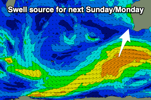
Longer term we see a strengthening polar frontal progression south-west of us, bringing some new mid-period SW swell next Sunday/Monday but we'll have a closer look at his Monday. Have a great Christmas!