Fun waves into Sunday, larger next week though windy
Western Australia Surf Forecast by Craig Brokensha (issued Friday December 17th)
Best Days: Sunday morning, Monday morning in the South West, protected spots Tuesday, Wednesday morning protected spots
Features of the Forecast (tl;dr)
- Large SW groundswell this afternoon, easing slowly through tomorrow, becoming mid-period energy on Sun
- Strong W/NW tending W/SW and S/SW winds later tomorrow
- Variable winds Sun AM, tending onshore into the PM
- Easing SW swell Mon with light to moderate SE tending S/SW winds (S/SE tending SW to the north)
- Building mix of large SW swells Tue with strong S/SE tending S/SW winds (S tending SW to the north)
- Easing surf Wed with fresh S/SE tending S/SW-SW winds
Recap
Good surf across the South West yesterday morning even with a touch of south in the wind with a drop in swell from Wednesday back to 5-6ft. Mandurah was fun in protected spots along with Perth on the small wave breaks.
A change moved through during the day bringing poor conditions and today we've got a continuation of poor conditions with a large, building SW groundswell.

Good surf yesterday morning
This weekend and next week (Dec 18 - 24)
Today we're seeing our large SW groundswell building across the state and the South West should reach 8-10ft on the sets, easing back from a similar size tomorrow morning. Mandurah looks to ease from 2-3ft with 2ft sets in Perth but conditions will be poor with strong W/NW tending W/SW winds, shifting S/SW later.
Sunday looks much better with winds going variable and light offshore as the swell eases back from a still solid though mid-period 6ft+ in the South West and 2ft to possibly 3ft across Mandurah and 2ft on the sets in Perth.
Get in through the morning as winds will shift onshore into the afternoon with a weak trough moving through.
Monday will be fun again with winds swinging back to the SE across the South West, S/SE to the north with a bit less swell.
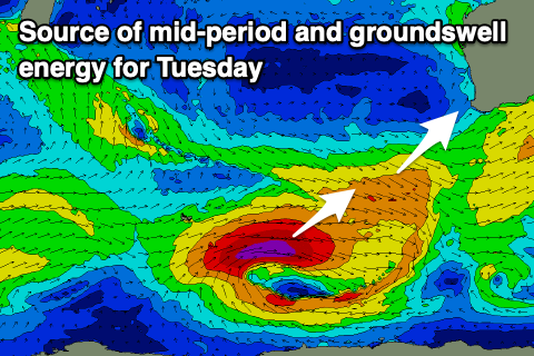
Moving into Tuesday we should see some new mid-period SW swell at dawn ahead of a larger SW groundswell into the afternoon.
 Both these swells will be generated by the same system, with a strong polar low firing up around the Heard Island region tomorrow. This will produce a fetch of severe-gale W/SW winds while just ahead of it, pre-frontal strong to gale-force W/NW winds.
The pre-frontal winds will generate the mid-period swell with the low producing the larger groundswell.
Building surf from the 6ft range in the South West to 10ft through the afternoon is due with building sets to 3ft across Mandurah and 2-3ft in Perth. Winds are an issue though with gusty S/SE breezes in the South West, S/SW into the afternoon. Strong S tending SW winds will kick in further north creating poor conditions as the swell builds.
The swell will ease through Wednesday with a little less strength to the winds but average, fresh S/SE breezes ahead of strong S/SW-SW sea breezes.
Margs may see a morning SE wind as the swell eases further, with nothing too significant to follow this activity into the Christmas weekend besides some new, windy mid-period S/SW swell. More on this Monday. Have a great weekend!

