Large swells to come, possibly XL next week

Western Australia Surf Forecast by Craig Brokensha (issued Wednesday December 15th)
Best Days: Keen surfers dawn tomorrow protected spots, possibly dawn Saturday Perth, Sunday Perth and Mandurah, protected spots Tuesday, Wednesday morning
Features of the Forecast (tl;dr)
- Smaller surf tomorrow with dawn S/SE tending S/SW and then SW winds
- Large building SW groundswell Fri with strong W/SW winds, easing Sat and still solid early with S/SE tending SW winds
- Further drop in swell Sun with variable tending SW
Recap
Poor surf yesterday and a lay day across most locations, though Mandurah offered a clean 1-2ft wave for the keen.
Today our new SW groundswell has filled in and conditions have cleaned up with 6-8ft surf in the South West, 2-3ft in Mandurah and 2ft across Perth. Make the most of this morning's clean conditions ahead of sea breezes.
This week and next (Dec 16 - 24)
Winds tomorrow will be less favourable as today's swell eases, S/SE at dawn but then quickly shifting S/SW and then SW through the day creating deteriorating conditions. Therefore if keen for a paddle try protected spots early.
Some new mid-period SW swell is due to build through the day ahead of our larger SW groundswell building Friday afternoon, easing through Saturday.
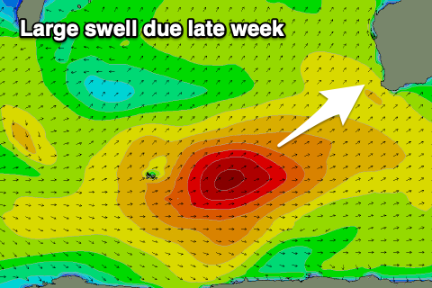 The strong frontal progression and polar low linked to this swell is now weakening south-west of us, but is still generating a fetch of strong W/SW winds.
We'll see the surf building to a strong 8-10ft across the South West into the late afternoon/evening Friday, easing back from a similar size on Saturday morning, with Mandurah peaking Saturday morning to 2-3ft with 2ft waves in Perth.
Unfortunately mid-latitude fronts will push in and across us and bring strong W/SW winds on Friday and then moderate to fresh W/SW winds on Saturday (possible variable at dawn on Saturday morning in Perth).
Come Sunday the swell will be still be a good size in the South West but more so mid-period energy , in the 6ft range with a persistent moderate W'ly wind. Perth and Mandurah should see light, morning offshore winds and easing sets from 2ft and 1-2ft respectively.
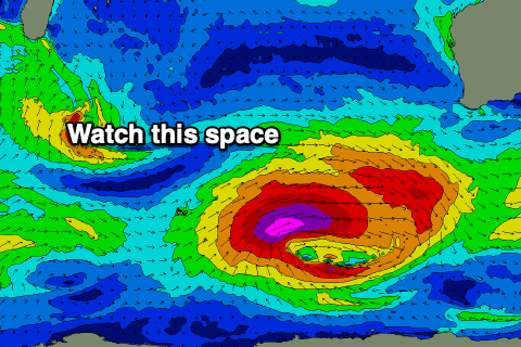 Moving into next week and we've got a significant upgrade in a polar low that's forecast to deepen south-west of us over the weekend.
The American GFS model is going strong with this system and 'bombing' it but the European model is more reserved so we'll meet somewhere in the middle. Either way we're likely to see a fetch of severe-gale to storm-force winds generating a significant SW groundswell Tuesday coming in at least 10-12ft in the South West, 3-4ft across Mandurah and 2-3ft in Perth.
Winds look to be best for protected spots and S/SE in nature, more SE on Wednesday as the swell eases, but more on this in the coming updates.