Plenty of swell inbound with workable winds

Western Australia Surf Forecast by Craig Brokensha (issued Monday December 13th)
Best Days: Wednesday morning, Saturday morning, early Sunday
Features of the Forecast (tl;dr)
- Large SW groundswell Wed with light SE tending strong SW winds, easing Thu with S tending S/SW winds
- Large building SW groundswell Fri with strong W/SW winds, easing Sat and still solid early with S/SE tending SW winds
- Further drop in swell Sun with variable tending SW winds
- Large, new SW groundswell early next week
Recap
Average, small, bumpy start to the weekend with onshore winds and a building SW groundswell into the afternoon. Yesterday was a bit cleaner though best in protected spots a peak in the SW groundswell, easing through the day and a little smaller today.
Today the swell has eased a bit more but conditions are even cleaner with great 5-6ft surf in the South West, tiny to the north in Perth and Mandurah.
This week and weekend (Dec 14 - 19)
Tomorrow is a lay day with a further drop in swell and S/SW winds in the wake of a trough and change today. Perth and Mandurah should see morning S/SE winds but they'll remain tiny.
Our large, new SW groundswell for Wednesday with favourable winds is on track
This swell was generated by a strong polar low firing up south-east of the Heard Island region late last week, generating a fetch of gale to severe-gale W'ly winds on the weekend. The low has since weakened and broken down south-west of us, with the swell due to arrive late tomorrow but peak Wednesday to a strong 8ft across the South West, 2ft in Mandurah and 1-2ft in Perth.
Conditions should clean up from Wednesday with an offshore SE breeze due across all locations ahead of strong S/SW sea breezes. Come Thursday the swell will ease but winds will revert to the S tending S/SW creating deteriorating conditions.
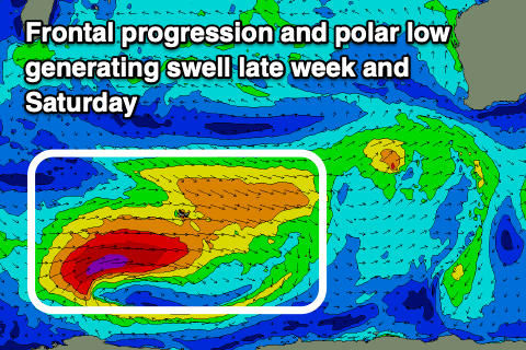 We then look at our larger SW groundswell into the weekend, generated by a secondary polar frontal progression and polar low firing up on the backside of today's polar low.
An initial pre-frontal fetch of strong to near gale-force W/NW winds will be followed by stronger, gale to severe-gale W/SW winds around the polar low, with some new mid-period SW swell due Thursday ahead of the larger SW groundswell energy filling in Friday. A peak is due later in the day/evening across the South West, with an easing trend into Saturday. Perth and Mandurah should peak Saturday morning.
The South West looks to come in at 8-10ft later Friday and early Saturday, with Mandurah seeing 2-3ft surf and 2ft waves in Perth.
Unfortunately the remnants of the frontal progression will move in Friday bringing strong W/SW winds, clearing Saturday leaving more variable winds in the South West, light S/SE-SE further north.
It looks like onshore winds will kick in again from Sunday as the swell continues to ease but we'll likely see a period of early variable winds. Check back here Wednesday for confirmation on this.
Longer term, another strong polar low looks to bring yet another large, long-period SW groundswell for early next week with favourable winds from the south-east. The size looks bigger than all the swells this period but we'll have a closer look at this on Wednesday.
Comments
I
Perfectly said.. I couldn’t agree more.
Tis the season
Plenty of GWS around at the moment as well