Windy though fun surf over the coming days

Western Australia Surf Forecast by Craig Brokensha (issued Friday December 3rd)
Best Days: Tomorrow, Wednesday morning, Thursday, Sunday morning protected spots, Monday morning in the South West
Features of the Forecast (tl;dr)
- New mid-period SW swell for tomorrow, peaking in the PM with strong E/SE tending S/SE winds (holding offshore Perth and Mandurah), easing Wed with strong E/NE tending SW winds (variable further north)
- Reinforcing, less consistent SW groundswell Thu with fresh NE tending lighter N/NW winds
- Smaller Fri with W/SW winds
- New SW groundswell arriving Sat PM, peaking Sun AM with moderate S/SE tending strong S/SW winds
- Easing swell Mon with fresh morning SE winds
Recap
Good clean conditions across the South West on Saturday with a further drop in swell from late week, 1-2ft in Mandurah and tiny across Perth.
Winds were a little less favourable and the swell more peaky yesterday but still fun in the South West, tiny further north.
Today is windier with the swell hanging in at that 3-4ft range again across the South West, best in semi-protected spots for the keen.
This week and weekend (Dec 7 - 12)
Looking at the week ahead and we've got some fun pulses of swell with favourable winds until Friday.
Firstly tomorrow a new mid-period SW swell is due across the state, with the best increase in size likely through the afternoon.
In saying this the morning won't be too much different in size to the afternoon, with the source of the swell being a broad fetch of below gale-force W/SW winds generated around the Heard Island region.
Margs should reach 5-6ft through the day with 1-2ft sets in Mandurah and 1-1.5ft in Perth. Conditions look good but windy with a strong E/SE offshore wind, remaining so into the afternoon in Perth and Mandurah, with S/SE winds in the South West.
Wednesday looks great again as the swell eases with a moderate to fresh E/NE offshore, giving into afternoon S/SW sea breezes in the South West, variable to the north.
Our secondary pulse of less consistent but stronger groundswell for Thursday is still on track with it likely showing late in the day Wednesday.
This was generated by a more distant fetch of W/NW gales behind the initial weaker fetch and should produce similar sized waves to tomorrow's peak but with a bit more strength and less consistency.
Winds will be more NE on Thursday, gusty through the morning, easing and tending N/NW into the afternoon ahead of a W/SW change on Friday as a weakening trough moves in.
The slow moving nature of this trough/front will leave lingering SW winds into Saturday with some new, inconsistent SW groundswell due into the afternoon, peaking Sunday morning.
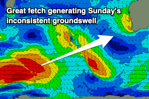 This swell will be another inconsistent one and similar though slightly larger to Thursday's, generated by a distant but great fetch of W/NW-W gales moving through our swell window, west of the Heard Island region over the coming days.
Inconsistent 6ft+ sets are due in the South West with 2ft sets in Mandurah and 1-2ft waves across Perth and with a S/SE tending S/SW breeze. Monday looks a bit cleaner as the swell eases with a SE offshore.
Longer term we may see a new, large W/SW groundswell for mid next week but local winds look an issue. More on this Wednesday.