Easing surf this weekend with fun swells next week

Western Australia Surf Forecast by Craig Brokensha (issued Friday December 3rd)
Best Days: Tomorrow morning in the South West and Mandurah, Tuesday morning in the South West and Mandurah, Wednesday and Thursday across exposed breaks
Features of the Forecast (tl;dr)
- Easing surf over the weekend with fresh morning E/SE winds tomorrow ahead of sea breezes, less favourable and S/SE on Sun
- New mid-period SW swell for Tue, peaking in the PM with strong E/SE tending S/SE winds, easing Wed with strong E tending variable winds
- Reinforcing, less consistent SW groundswell Thu with fresh E/NE tending light N winds
Recap
A large swell with bumpy conditions early across the Margarer River region yesterday with surf in the 8ft range, cleaning up as the morning progressed before sea breezes kicked in. Perth and Mandurah were also a little bumpy with S/SE winds and 2-3ft waves on the former, 2ft on the latter.
Today conditions were cleaner across Perth and Mandurah but with a little less size, easing from 1-2ft in Perth and 2-3ft across Mandurah. Margs was back to the 6ft range and windy with strong E/SE-SE winds. Semi-protected breaks are cleanest and best.

Still a bit of size around this morning
This weekend and next week (Dec 4 - 10)
The current swell is easing slowly across the state and we'll see a further drop in size tomorrow along with offshore winds though not as strong as today. A fresh E/SE breeze is due tomorrow morning with easing surf from the 4-5ft range in the South West, 1-2ft in Mandurah and 1-1.5ft across Perth. Afternoon sea breezes will get into the waves after lunch so make the most of the morning.
Sunday looks less ideal with a further drop in size and a shift to unfavourable S/SE breezes, similar Monday with stronger SE-S/SE winds but no new swell until late in the day (that being a moderate sized mid-period SW swell).
This new, mid-period energy which is expected to peak Tuesday will be generated by developing frontal progression in the Heard Island region today.
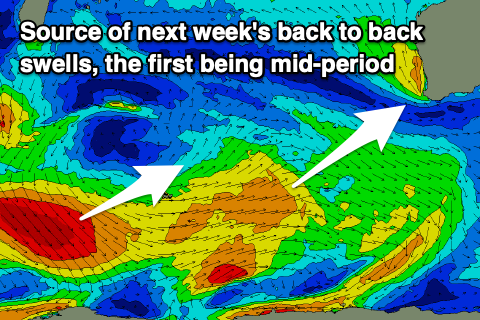 A broad fetch of not overly strong, below gale-force W/SW winds will be generated through our south-western swell window, producing a mid-period SW swell that should come in at 5-6ft in the South West, 1-2ft in Mandurah and 1-1.5ft across Perth. The peak is due through the afternoon but the morning only looks to be a little under this size.
Conditions will be windy but more offshore Tuesday morning with strong E/SE breezes due ahead of S/SE winds into the afternoon.
We'll see the swell ease back in size Wednesday but with strong E'ly offshore winds and hot weather as a heat trough deepens north of us. This will likely keep winds favourable into the afternoon, easing and tending E/NE which will provide a full fun day of surf.
Our secondary pulse of reinforcing SW groundswell for Thursday is on track with a trailing fetch of W/NW gales due to produce the energy. It looks to be similar in size though less consistent to Tuesday's swell, peaking Thursday morning. Winds look fresh from the E/NE, tending variable out of the N as the heat trough drifts south across us, with less favourable, cooler W/SW winds likely in its wake on Friday.
Following this we may see winds linger onshore into the weekend with small swells, but the models diverge slightly regarding the local winds and swells. More on this in Monday's update. Have a great weekend!