Large swell with clean morning windows

Western Australia Surf Forecast by Craig Brokensha (issued Wednesday December 1st)
Best Days: Every morning this period besides Sunday and Monday when the size bottoms out
Features of the Forecast (tl;dr)
- Large mix of SW groundswells tomorrow with light E/SE-SE tending strong S/SW winds
- Easing SW groundswell Fri with strong SE tending S/SE winds
- Smaller surf Sat with fresh E/SE winds ahead of sea breezes
- Building mid-period SW swell late Mon, peaking Tue with E/SE tending S/SW winds
- Secondary pulse of SW groundswell Thu with E/SE tending SW winds
Recap
Average conditions yesterday with an easing swell from Monday across the South West, while Mandurah saw clean 1-2ft waves, tiny in Perth while being a little wind affected.
Today winds are still average in the South West but we've got some new swell showing on the coast, starting around 4ft this morning but now pushing towards 5-6ft on the sets. Mandurah was the pick with clean conditions and 2ft sets, peaky and small to 1-2ft across Perth.
Our first pulse of large SW groundswell should provide larger sets to 6-8ft+ this afternoon, reaching 2ft+ across Mandurah and 2ft in Perth but the coming days look the best regarding surfing.

Building surf in the South West
This week and next (Dec 2 - 10)
This afternoon's building swell was linked to a strong polar low that developed around the Heard Island region on the weekend and we're due to see a larger, reinforcing pulse of SW groundswell filling in tomorrow, produced by a secondary, tight low forming south-west of us last night.
 This low will is short-lived and already tracking east out of our swell window, but with an additional fetch of SW gales aimed towards us we should see good 8ft+ surf in the South West tomorrow, 3ft sets across Mandurah and 2ft+ waves in Perth.
Conditions are looking better with a light to moderate E/SE-SE offshore across Margs, SE further north ahead of strong S-S/SW breezes.
The swell will ease back through Friday from 6ft to possibly 8ft in the South West, 2ft to nearly 3ft in Mandurah and 2ft on the sets across Perth but and with stronger SE tending S/SE winds.
Saturday looks cleanest with the most size with a moderate to fresh E/SE offshore and easing surf from 4-6ft in the South West, 2ft across Mandurah on the sets and a tiny 1-1.5ft in Perth.
Winds should still be OK on Sunday and from the SE in the morning but the swell will be smaller, weaker and easing.
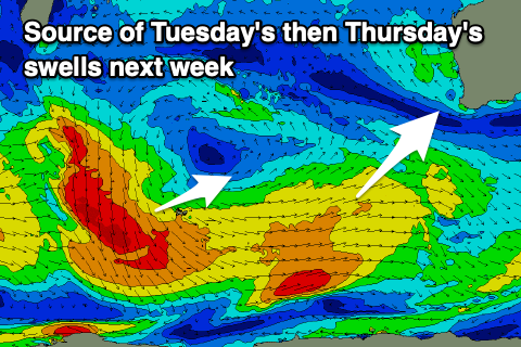 Into next week, some new, moderate sized mid-period SW swell is due to fill in, produced by broad but not overly strong frontal activity east of the Heard Island region. We may see a stronger fetch of pre-frontal NW winds fire up on the backside of this progression Sunday, producing a stronger groundswell signal, but we'll review this Friday.
The initial activity should produce a good pulse of mid-period swell for Tuesday to 6ft in the South West, small in Mandurah and Perth to 2ft, with the secondary, similar sized pulse of groundswell for Thursday. Winds look great and E/SE each morning but we'll confirm this Friday.