Large swell this week though windy

Western Australia Surf Forecast by Craig Brokensha (issued Monday November 29th)
Best Days: Protected spots Wednesday, Thursday and Friday, more exposed spots Saturday and Sunday mornings as well as early-mid next week
Features of the Forecast (tl;dr)
- Weak, easing SW swell tomorrow with S/SE tending SW winds
- Large, building SW swell Wed with fresh S/SE tending SW winds, peaking Thu with gusty S/SE-SE winds
- Easing SW swell Fri with strong SE tending S/SE winds, smaller Sat with a morning E/SE wind
Recap
Our reinforcing swell for Saturday provided good options in the South West with clean 3-4ft+ surf, tiny and to 1-1.5ft in Mandurah and smaller across Perth.
Yesterday was average with a drop in swell and onshore winds.
This week and weekend (Nov 30 – Dec 5)
This afternoon's spike in swell is due to ease back through tomorrow and winds will be a little more favourable than today, though still less than ideal with a morning S/SE breeze, shifting SW and strengthening into the afternoon.
Size wise the South West looks to ease back from the 4ft range, tiny and to 1-1.5ft in Perth and Mandurah.
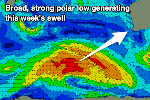 Our better and prolonged SW swell event for mid-late week is on track, with a broad, slow moving polar low forming in the Heard Island region over the weekend. A fetch of gale-force W-W/SW winds were generated through our south-western swell window, with the low now weakening while pushing further east.
We'll see this generate a large, mid-period SW swell for Wednesday, building into the afternoon, while a secondary embedded front will generate some reinforcing energy on Thursday.
Size wise the South West should build to 6-8ft+ through Wednesday with 2ft+ sets across Mandurah and 2ft sets in Perth, peaking Thursday to 8ft+ in the South West, 2-3ft sets across Mandurah and 2ft+ in Perth.
Winds on Wednesday are OK but not great and will be S/SE through the morning ahead of SW sea breezes, with Thursday looking a bit better under gusty S/SE-SE winds through the morning, stronger S/SE into the afternoon (S/SW Perth and Mandurah).
Unfortunately winds will persist out of the SE on Friday and be strong as the swell eases, with E/SE offshore winds kicking in Saturday but when the swell becomes smaller.
Longer term, some healthy polar frontal activity skirting around a strong high to our west should generate some fun S/SW swell for next week with morning offshore winds. We'll have a closer look at this in the coming updates.