Fun tomorrow morning then average until later next week

Western Australia Surf Forecast by Craig Brokensha (issued Friday November 26th)
Best Days: Keen surfers tomorrow morning in the South West, Wednesday morning protected spots, Thursday morning, Friday morning
Features of the Forecast (tl;dr)
- Inconsistent, small, mid-period W/SW swell Sat with a light-mod morning SE wind ahead of sea breezes
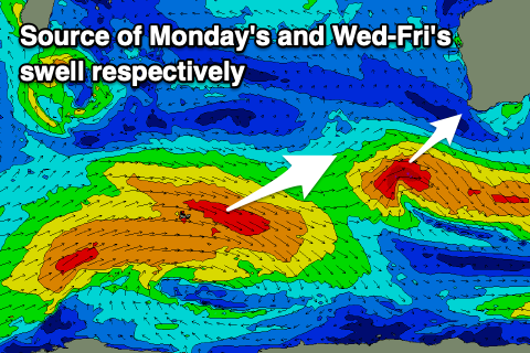
- New mid-period SW swell Mon with S-S/SW winds, easing Tue with similar winds
- Large, mid-period SW swell building Wed PM, peaking Thu with S/SE tending SW winds on Wed and fresh SE tending S/SW winds Thu
- Easing SW swell Fri with E tending W/SW winds
Recap
A drop in swell and fairly decent conditions across the South West yesterday morning but not as good as Wednesday. Perth and Mandurah were also more peaky and small to tiny.
Today there's been a reinforcing pulse of swell in the South West with cleaner conditions and good 4-5ft sets on the magnets. Perth and Mandurah have remained tiny.
This weekend and next week (Nov 27 – Dec 3)
Tomorrow morning should be fun across the South West magnets again with another reinforcing pulse of W/SW though this will be fairly inconsistent and mid-period energy from the west.
Winds look light to moderate from the SE with 3-4ft sets in the South West, tiny across Perth and Mandurah.
 Sunday now looks average with a trough bringing unfavourable S-S/SW winds that will likely be more variable early up the coast but the swell tiny.
Our new pulse of swell for early next week is on track but it looks a touch smaller than expected on Wednesday with the pre-frontal fetch of W/NW winds being faster moving, weaker and less favourably aligned.
Instead we're only due to see a moderate sized pulse of mid-period SW swell for Monday, coming in at 4-5ft or so with tiny surf continuing in Mandurah and Perth. Unfortunately winds will remain out of the S'th creating average conditions, similar as it eases on Tuesday but luckily we've got better surf due into the end of the week.
The source of a better run of swell will be a broad, slow moving but not overly strong polar frontal progression forming in the Heard Island region tomorrow. A fetch of slow moving strong to gale-force W/NW tending W/SW winds will move through our south-western swell window, producing a prolonged, large, mid-period SW swell for later Wednesday and Thursday.
We may see a secondary frontal system firing up on the tail of the progression generating a bit more size Thursday than currently forecast. Check back Monday for more on this.
The swell should build to 6ft to occasionally 8ft Wednesday afternoon in the South West, 2ft on the sets across Mandurah and 1-2ft in Perth, peaking Thursday to a more consolidated 6-8ft, 2ft+ and 2ft respectively. Winds will be favourable from the S/SE tending SW on Wednesday but best Thursday and more SE through the morning. Friday looks cleaner with a straight E'ly offshore as the swell eases but we'll confirm this Monday. Have a great weekend!
Comments
Margs looking good this AM.
Wow, roguey? Buoy readings are very sub-par.
Was good fun, Craig
Nice, how big?
Pressure is on Clivus
Daily report accurate, Craigo. 3-4ft/ 6-8ft Victorian, Bnknref
Ha Ha
And 10-12ft and tow-ins only in Queensland haha
been crap up north since tuesday or wednesday.
Craig or Ben why dont you include mid and nw coast anymore in the forecast notes?
Is it due to variable winds or harder to predict? or too many other locations to focus on? seems like whenever the forecast says it will be ese winds its NE or when it says sse winds its SE early...Not a complaint even earth nullschool says its se winds here today and its actually northerlies, only one place offshore in northerlies up here which is a c grade beachy two hours away.
Midwest summer wind forecast: It's going to be south, with a bit of extra south, maybe some south-south west. Wind strength is stronk. If you are particularly unlucky, the SSW sea breeze will come in at 6:30am and everyone says "you should have been here at 6".
Also do you guys keep forecasts in archives? wouldn't be a bad idea to have archives of swell events on your website.