Smaller run of surf, better swells next week though not as clean

Western Australia Surf Forecast by Craig Brokensha (issued Wednesday November 24th)
Best Days: This morning, tomorrow morning in the South West, Saturday morning in the South West, protected spots Monday and Tuesday mornings
Features of the Forecast (tl;dr)
- Easing W/SW swell with mod-fresh E/SE-SE winds tomorrow morning, fading Fri with light E/SE morning winds
- Inconsistent, small, mid-period W/SW swell Sat with a light morning E/SE wind
- New SW groundswell Mon with S/SE tending SW winds, easing Tue with S/SE tending S winds
- Possible better groundswell late week with S winds
Recap
All coasts saw a lift in swell yesterday morning with an improvement in local winds and surfable conditions, coming in around 4-5ft in the South West and 1-2ft across Mandurah and Perth.
A stronger pulse of W/SW groundswell filled in through the day though and this has held well into this morning with much cleaner conditions and easing sets from 6ft to occasionally 8ft in the South West, 2ft in Mandurah and 1-2ft across Perth.

Great surf this morning
This week and weekend (Nov 25 - 28)
This morning’s W/SW groundswell will ease through today and drop further into the end of the week, with clean conditions better suited to the South West as the size dwindles.
 Conditions tomorrow will be clean with a moderate to fresh E/SE-SE offshore in the South West, E’ly in Perth and Mandurah with easing sets from 4ft+ range, 1-1.5ft in Mandurah and Perth.
Friday looks weak, with small leftovers under lighter E/SE offshore winds ahead of SW sea breezes.
Into Saturday our small pulse of weak, mid-period W/SW swell is still on the cards, generated by a relatively weak front pushing up and north of the Heard Island region yesterday. No size is due in Perth and Mandurah while Margs should offer 3-4ft sets on the magnets with a light, morning E/SE breeze.
On Sunday winds will deteriorate as a trough moves in, followed by a high pressure system, bringing S/SW winds to the South West and N/NE tending SW winds across Perth and Mandurah as the swell bottoms out.
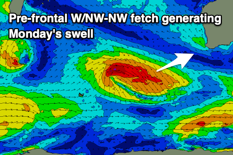
With the high setting up camp west of us, S/SE winds are due to persist Monday and Tuesday with a new SW groundswell due on the former. The source of this swell will be a tropical low off the South African coast, drifting into the westerly storm track (resulting in it deepening) with a fetch of strong to gale-force NW-W/NW winds pushing east-southeast through our swell window.
The swell looks to come in around 5-6ft across the South West with 1-2ft sets in Mandurah and tiny surf across Perth.
Behind this system we may see a better aligned polar front projecting up towards us Friday through Sunday, generating a new swell late week but with persistent S’ly winds. We’ll take a closer look at this on Friday.