Improving surf from next week

Western Australia Surf Forecast by Craig Brokensha (issued Wednesday November 17th)
Best Days: Tuesday morning, Wednesday morning protected spots, Friday next week
Features of the Forecast (tl;dr)
- Easing S/SW swell tomorrow with strong SE tending S/SE winds
- Small S/SW swell Fri with fresh SE tending S/SW winds, easing Sat with E/NE tending NW winds
- Weak SW windswell building Sun with S/SW winds
- Small, mid-period SW swell Mon with S/SW winds
- Better, inconsistent W/SW swell for Tuesday, peaking through the day with E tending SW winds ahead of a late S change
- Easing swell Wed with S/SE winds
- Good W/SW swell Fri with morning E winds
Recap
Tiny, wind affected waves in the South West yesterday, cleaner to the north but with no real size. Onshore winds kicked up a tiny windswell in Perth through the afternoon but this has faded today leaving, peaky, clean, tiny surf.
There’s been a slight lift in swell across the South West with 2-3ft sets along with a slight improvement in local winds. Semi-protected small wave breaks are the pick.
This week and next (Nov 18 - 26)
There’s a few more days of average surf due across the state before we see more activity into next week.
We’ll see the surf remaining on the small to tiny side through tomorrow as winds persist from the south-east, strong in strength. Any swell seen today in the South West (background energy) is due to ease through tomorrow, limiting options for a wave.
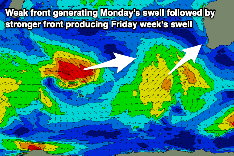
Slightly weaker, though still gusty SE breezes are due into Friday morning along with a small pulse of new, mid-period S/SW swell. As stated in Monday’s notes, the source is flukey and I can’t see Margs getting above 2-3ft on the swell magnets, tiny to flat to the north.
Cleaner conditions will be seen Saturday with an E/NE tending NW breeze but with smaller, fading surf from 2ft or so.
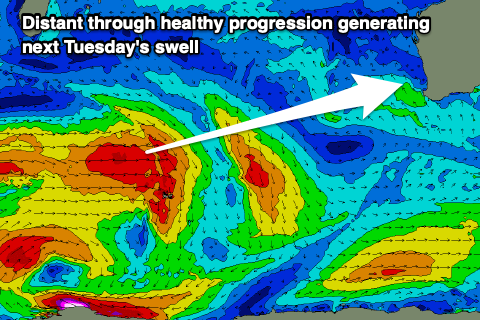 We then look at the better frontal activity firing up south-east of Madagascar from today.
What’s forecast to take place is a multi-staged frontal progression with various fetches of W/SW gales projected through our medium to far swell window. While not consolidated we’ll still see the back to back activity generate some fun, inconsistent swell, coming in around the moderate sized range.
The front pushing ahead of the swell towards us later this week and weekend looks a little weaker and as a result we’re not expected to see much in the way of size later Sunday with it being mostly windswelly energy and onshore in any case.
Come Monday there should be a little more push to the swell but expect surf to 3-5ft in the South West, tiny to the north and with lingering S/SW winds as the front clips the state.
 The better, longer-range energy is due to arrive through Tuesday, building to a fun 5-6ft across the South West, 1-2ft in Mandurah and Perth. Winds should improve and swing light offshore during the morning across all locations ahead of afternoon sea breezes and a late S’ly change as another trough moves through. This trough will unfortunately leave S/SE winds into Wednesday morning across the South West as the swell starts to ease, better and variable further north ahead of strong S/SW sea breezes.
Come Friday a reinforcing pulse of mid-period swell is on the cards, generated by a good fetch of strong to gale-force W/NW winds pushing in from north of the Heard Island region. This also looks to be met with fresh E’ly winds, but we’ll have a closer look at this on Friday.