Poor week, better next

Western Australia Surf Forecast by Craig Brokensha (issued Monday November 15th)
Best Days: Protected spots next Monday and Tuesday morning, Wednesday morning next week
Features of the Forecast (tl;dr)
- Fading S/SW swell tomorrow with strong S/SE tending S/SW winds (variable to the north in the AM)
- No swell and strong SE winds Wed/Thu
- Small S/SW swell Fri with gusty S/SE-SE winds
- Easing surf Sat with E tending SW winds
- Building mid-period SW swell late Sun with SE tending SW winds, peaking Mon AM with gusty S/SE winds
- Better mid-period SW swell for Mon PM and Tue with SE tending S/SW winds, easing Wed with E/SE morning winds
Recap
Small to tiny. That was the surf on the weekend with a small pulse of S/SW swell seen Friday in the South West dropping back Saturday under clean conditions, bottoming out Sunday.
Today a new S/SW swell is providing a little bump in swell across the south magnets in the South West but only to 3ft, slightly under the expected 3-4ft. Conditions are favourable while Perth and Mandurah remain tiny.

Small lift in swell today
This week and weekend (Nov 16 - 21)
This morning was expected to be the best surf day of the week, and seeing at the performance across the South West, it doesn't bode well for the coming period.
We'll see the swell fading through tomorrow leading to a bottoming out of the surf, persisting Wednesday and Thursday.
 Conditions won't be as favourable tomorrow as a small low pushes east, bringing fresh to strong S/SE tending S/SW winds to the South West, variable early to the north then out of the W.
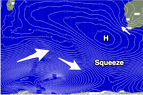
Winds will slowly improve Wednesday, swinging SE but remaining strong across the South West, similar Thursday as frontal activity in the south-west Indian Ocean squeezes a high to our south-west.
On Friday a small and very flukey mid-period S/SW swell is showing on the charts but the source winds look suspect and local winds will be poor in any case. I would only expect 2ft to maybe 3ft sets on the south swell magnets Friday in the South West along with gusty S/SE-SE winds. Not ideal at all. Perth and Mandurah will remain tiny to flat.
This swell will fade into Saturday as winds ease and swing to the E but again there'll be no size to surf, expect fading 1-2ft waves.
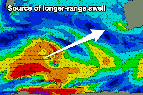
 As touched on in Friday's update, we've got more activity from Sunday but more so next week from the activity firing up in the south-east of Madagascar, then pushing east towards us.
While not overly strong it is healthy with a multi-staged frontal progression due to project varying fetches of W/SW gales towards us. This will produce mid-period energy in the moderate sized+ range.
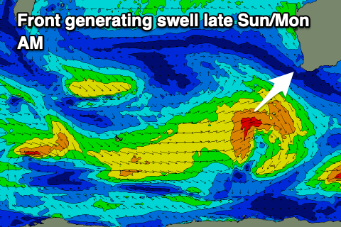
One of the frontal systems will race ahead of the swell it's generating and push close towards us Saturday before dipping away Sunday. This will produce the first pulse of mid-period swell that should build Sunday afternoon and reach 4-5ft by dark in the South West before peaking Monday morning to 4-6ft. Mandurah should see 1-2ft waves on Monday with 1-1.5ft surf in Perth.
 Winds on Sunday afternoon will tend SW as the front clips the state, reverting back to the S/SE on Monday which isn't ideal.
We'll see some stronger swell fill in Monday afternoon followed by a secondary pulse Tuesday from the stronger, more distant fetches, likely peaking to 6ft+ in the South West, 2ft+ in Mandurah and 1-2ft across Perth. Winds look a touch better Tuesday and more SE through the morning and offshore out of the E/SE Wednesday as the swell eases, but we'll confirm this Wednesday and Friday.