Very slow period with not much to work with

Western Australia Surf Forecast by Craig Brokensha (issued Monday November 8th)
Best Days: Monday morning next week in the South West
Features of the Forecast (tl;dr)
- Fading S/SW swell over the coming days with strong SE tending S/SE winds tomorrow, fresh E/SE tending S/SW winds on Wed
- Low point in swell Thu
- Small, weak S/SW swell for late Fri, easing Sat with E/SE tending S/SW winds
- Better, though small, mid-period S/SW swell building Sun PM, easing Mon with E/NE tending NW winds
- Possible fun SW groundswell mid-next week
Recap
A great weekend of surf with a new, building S/SW swell on Saturday with light morning winds and clean conditions, increasing from 5-6ft in the South West, 1-2ft across Mandurah and Perth.
Sunday morning was clean with the swell from Saturday afternoon easing back from the 6ft range in the South West, and 2ft further north on the sets.
Today the swell is smaller and dropping from 3ft across the South West, tiny in Perth and Mandurah.
This week and weekend (Nov 9 - 14)
I hope you made the most of the weekend's swell and waves, as the coming period is looking slow and weak.
 Perth and Mandurah will remain on the tiny side of the coin with afternoon increases in local windswell associated with sea breezes due to fade into the next morning as offshore winds kick back in. To maximise the cycle try the dawn sessions if desperate.
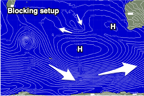
Looking to the south and a persistent blocking pattern will keep our main swell windows quiet through this week with any potential swell generating system moving in from under South Africa and Madagascar due to be deflected to the south-east, only reaching up back for air when approaching Victoria.
This isn't favourable at all, with small, mid-period S/SW swells being the end result, spreading radially up from the weak polar frontal activity.
Winds will be generally favourable owing to the stationary nature of the high, directing persistent E/SE-SE winds across all regions. Tomorrow will see strong SE tending S/SE winds, lighter and more fresh from the E/SE on Wednesday ahead of S/SW sea breezes.
Size wise there's no new swell due with the South West coming in around the 3ft range tomorrow, easing Wednesday from 2-3ft max on the swell magnets, tiny elsewhere.
The surf looks to bottom out on Thursday with a light morning E/SE-SE offshore ahead of sea breezes.
 The charts are showing a small increase in size on Friday afternoon but this will be weak and unlikely to top 2-3ft (on the south swell magnets) with sea breezes, easing from a similar size on Saturday morning. Winds will be best Saturday morning so if desperate for a surf, aim for this window on the south swell magnets.
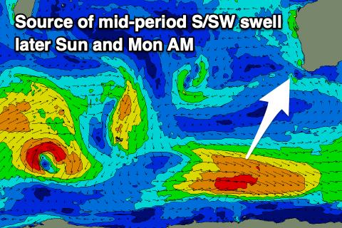
A slightly better pulse of mid-period S/SW swell is on the cards for Sunday afternoon and more so Monday morning, produced by stronger near-gale force W/NW winds, late in our swell window on the polar shelf Thursday. The swell may provide better 3ft to possibly 4ft sets next Monday morning with an E/NE offshore ahead of a change as a trough pushes through.
Longer term we may see a better, moderate sized groundswell for mid-next week, but we'll have a closer look at this on Wednesday.