Easing, clean surf, becoming large and windy again from late week

Western Australia Surf Forecast by Craig Brokensha (issued Monday August 23rd)
Best Days: Today, tomorrow, the South West Wednesday, Perth and Mandurah Saturday morning, protected spots in the South West
Features of the Forecast (tl;dr)
- Easing SW groundswell tomorrow with strong E/NE winds, easing into the PM
- Building SW groundswell Wed PM with strong E/NE tending NE and then N winds, easing late
- Strengthening W/SW winds Thu with a large, mid-period W/SW swell for Fri with strong SW tending S/SW winds
- Large SW groundswell Sat with fresh S tending S/SW winds in the South West (SE in the morning across Perth and Mandurah)
- Strengthening W winds Sun, W/NW Mon with a large, building SW groundswell, XL Tue AM with W/NW winds
Recap
Poor conditions across all locations Saturday with fresh to strong onshore winds but a new, large, mid-period W/SW swell in the water.
This swell held into yesterday morning with slightly better winds across Perth and Mandurah, best in protected spots with 3ft surf in Mandurah and 2-3ft waves across Perth. Margs was large and to 10ft+, best in protected spots with a larger, more powerful SW groundswell filling in through the afternoon.
Conditions improved late yesterday across all locations as a high slid in behind the frontal activity, with excellent surf on offer today with a large, easing SW groundswell. Margs was a clean 8-10ft, 3-4ft in Mandurah and 3ft across Perth.

Pumping waves this AM
This week and weekend (Aug 24 - 29)
Make the most of today and the coming days before winds swing back onshore into Thursday.
We'll see the weekend's swell continuing to ease into tomorrow with stronger E/NE winds in the morning, easing off into the afternoon, becoming variable late. The South West should see sets easing from the 5-6ft range, 2ft+ in Mandurah and 1-2ft across Perth.
 Wednesday morning looks temporarily smaller ahead of a new, inconsistent SW groundswell showing through the day. This swell was generated by a distant but strong storm firing up south-east of South Africa, and should produce inconsistent 4-5ft+ sets across Margs into the afternoon, 1-2ft in Mandurah and tiny across Perth.
Winds will be OK early and strong from the E/NE but shifting NE and then N into the afternoon before easing later.
This will be ahead of a change which will move in Thursday, bringing strong W/SW winds too all locations, strengthening further through the day.
This will be linked to a strong polar front firing up around Heard Island tomorrow, projecting W/SW gales towards us while weakening, pushing through as a mid-latitude front on Thursday.
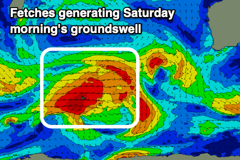
Building mid-period energy is due later Thursday and more so Friday ahead of the groundswell later in the day, peaking Saturday morning.
Strong SW tending S/SW winds will be seen on Friday with the South West kicking to 6-8ft, 2-3ft in Mandurah and 2ft+ across Perth. Saturday should reveal stronger 8ft sets in the South West, 2-3ft in Mandurah and 2ft+ across Perth but with better SE winds across the northern regions, gusty S around Margs.
 Unfortunately it looks like the next frontal progression will move in quickly, bringing strengthen W winds on Sunday, W/NW on Monday.
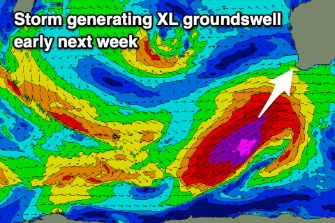
The frontal progression linked to these onshore winds will be a significant one, with a polar front firing up south-west of us on the weekend, projecting storm-force SW winds through our swell window.
An XL, long-period SW groundswell is due from this progression, building later Monday but peaking Tuesday though with W/SW winds. The South West looks to be 12-15ft, 3-4ft+ across Mandurah and 3ft+ in Perth.
It looks like a secondary front firing up behind this initial system will bring onshore winds into Wednesday as it eases, but we'll have a closer look at this Wednesday.
Comments
Nugget popping gorfs at the box, classic!