Building swells with small windows, best from Sunday/Monday

Western Australia Surf Forecast by Craig Brokensha (issued Wednesday August 18th)
Best Days: Perth and Mandurah Friday and Saturday mornings, Sunday, Monday and Tuesday all locations
Features of the Forecast (tl;dr)
- Building W/SW swell tomorrow PM with variable morning winds, tending fresh W/SW into the PM
- Swell persisting Fri with fresh to strong W/SW winds in the South West, variable for period in Perth and Mandurah
- Large, mid-period W/SW swell for Sat with fresh to strong W/SW winds in the South West, variable for period in Perth and Mandurah
- Large SW groundswell building Sun, peaking into the PM with mod-fresh S/SW winds in the South West, tending S/SE late (fresh S/SE-SE tending S/SW in Perth and Mandurah)
- Large, easing SW swell Mon with morning offshore winds and late sea breezes
- Smaller Tue with gusty E winds
Recap
Firstly thoughts go out to the family, friends and wider surfing community in regards to Frank Hayter's death at Main Break Monday. Yesterday dawned clean and offshore with 4-6ft of swell across the region, smaller and fun in Perth and Mandurah.
This morning more variable winds provided mixed conditions with the South West best early along with a new, reinforcing swell to 4-6ft, 2ft in Perth and Mandurah with conditions still remaining clean.
This week and weekend (Aug 19 - 22)
I hope you've made the most of the recent run of clean swell as we'll move back into a temporary onshore pattern from tomorrow that will last until Sunday.
The source of onshore winds will be initially mid-latitude frontal system backed up by a stronger polar low sweeping through late week, generating a large, new SW groundswell for the weekend.
 Looking at tomorrow and we'll see the current swell dropping back in size tomorrow morning ahead of a new W/SW groundswell into the afternoon. The only issue are the local winds and hi-res modelling has variable breezes due across all locations through the early morning, giving into freshening onshore W/SW winds through the afternoon when this new swell fills in.
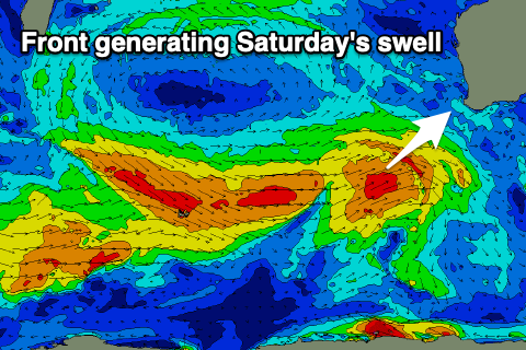
The source of the swell was a short-lived low that fired up south-west of us earlier this week with the South West due to kick back to 6ft on the sets, 2ft in Perth and Mandurah.
Friday looks to come in around a similar size but with fresh to strong W/SW winds in the South West, easing through the day. Perth and Mandurah are likely to see a window of variable winds, creating OK conditions for the keen.
Moving into the weekend and another pulse of mid-period W/SW swell is due Saturday from a good fetch of strong to gale-force W/SW winds projecting up and towards us today and tomorrow.
The swell from this system looks a bit bigger than tomorrow afternoon's, with 6-8ft sets due across the South West, 2-3ft in Mandurah and 2ft+ across Perth. Winds will be similar to Friday though and fresh to strong W/SW across the South West with a window of variable winds possible early in Perth and Mandurah.
We then look at the stronger polar low that's due to fire up south-west of us tomorrow evening, and this system should project a great fetch of gale to severe-gale W/SW tending SW winds through our south-western swell window.
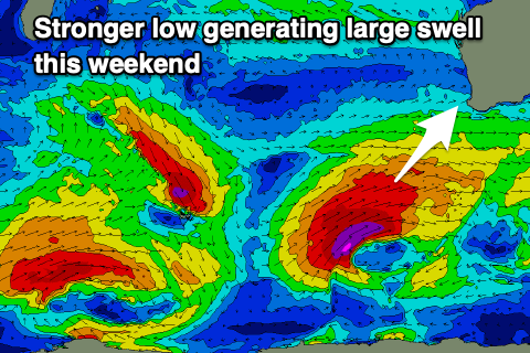 The swell from this low will be large, long-period and consistent, filling in Sunday and peaking through the afternoon to 12ft+ in the South West, 3-4ft in Mandurah and 3ft across Perth.
The low will push off to the east on Sunday resulting in winds swinging S/SW across Margs in the morning and S/SE late in the day, with S/SE-SE winds further north in the morning, S/SW into the afternoon.
Monday is the pick though with large easing sets from the 10-12ft range across the South West, 3ft+ in Mandurah and 2-3ft in Perth with E-E/NE offshores in the South West, E further north, tending variable ahead of late sea breezes.
Tuesday looks clean all day but smaller with fresh to strong E/SE-E winds.
Longer term smaller swells are due into the end of the week and a deepening trough/low may bring average winds but more on this Friday.