XL stormy swell to come, settling from late week

Western Australia Surf Forecast by Craig Brokensha (issued Monday August 9th)
Best Days: Perth Wednesday morning, Perth and Mandurah Thursday, Friday morning select locations, Sunday all locations, Monday in the South West
Features of the Forecast (tl;dr)
- XL W/SW groundswell tomorrow with strong to possibly gale-force W/SW tending SW winds later
- Easing XL W/SW groundswell Wed with fresh to strong SW tending W/SW winds (variable early around Perth)
- Easing large, mid-period SW swell Thu with light-mod W/SW winds in the South West, NE in the AM further north
- Large SW groundswell for Fri with N/NE tending N/NW winds in the South West, NE early further north
- Easing swell Sat with strong S/SW winds
- Good mod-large W/SW swell Sun with E tending variable winds
Recap
The great surf seen into the end of the week started to deteriorate through the weekend, with strengthening winds from the N'th limiting surfing options as Friday's swell eased in size.
Sunday was smaller and still OK early (surprisingly) before winds shifted onshore and with strength ahead of a trough.
Today we've got large, stormy surf across all locations which will build further through the day as a vigorous polar frontal progression pushes up and across us.
This week and weekend (Aug 10 - 15)
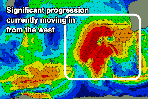 Winds are strengthening across the coastal margin this afternoon as a vigorous cold front approaches from the west, associated with a significant polar frontal progression that developed over the weekend.
With fetches of severe-gale to storm-force W/SW winds projected into us, there's no change to the expected XL swell across the state tomorrow with the South West coming in around 15-20ft, 4-6ft in Mandurah and 3-5ft across Perth. Conditions will still be a complete, stormy mess with strong to at times possibly gale-force W/SW winds, shifting SW later in the day.
The swell still looks to be XL in size early Wednesday owing to the back to back frontal systems pushing up and into us, with Margs easing from 15ft+, 4-5ft in Mandurah and 4ft across Perth with a slight improvement in the local winds.
Margs will remain onshore with fresh to strong SW tending W/SW winds, but Perth looks to see variable E/NE winds. Mandurah is touch and go at the moment but looks less likely to see those early light winds.
Thursday is a much better chance with variable NE winds due across Perth and Mandurah in the morning, lingering light to moderate W/SW across Margs.
Size wise, the swell will be weaker and mid-period energy from the SW on Thursday, likely still 8ft or so in the South West and easing, dropping from 3ft in Mandurah and 2-3ft in Perth.
Into Friday though we've got a great pulse of new SW groundswell, generated by pre-frontal W/NW gales moving through our swell window mid-week.
This should keep the South West around 6-8ft, 2ft+ in Mandurah and 2ft in Perth along with better winds for the South West. It won't be ideal but an early N/NE breeze will shift N/NW, favouring selected breaks, with NE tending N/NW winds further north.
 The northerly will be ahead of a trough and a strong S/SW change on Saturday, spoiling the easing swell with straight offshore winds due across all spots Sunday along with a new, mid-period W/SW swell.
The source of this swell will be a persistent though relatively weak mid-latitude front pushing through the southern Indian Ocean.
The swell looks to be in the 6ft+ range across the South West, 2-3ft in Mandurah and Perth.
Following this another mid-latitude system firing up south-east of Madagascar may generate a stronger swell mid next week, but more on this Wednesday.