Large windy surf, slowly improving from Wednesday

Western Australia Surf Forecast by Craig Brokensha (issued Monday June 28th)
Best Days: Perth and Mandurah Wednesday, Thursday all locations (improving through the day around Margs), Friday morning all locations
Features of the Forecast (tl;dr)
- Large, mid-period W/SW swell tomorrow with strong W/SW-SW winds, easing late in the day
- Large SW groundswell Wed with mod-fresh W/NW winds, strengthening through the day (E/NE-NE tending variable Perth and Mandurah)
- Easing SW swell Thu, slowed slightly by a reinforcing pulse with variable winds, smaller Fri with NE tending NW winds
- Windy, large swells into early-mid next week owing to mid-latitude lows
Recap
Workable waves for the desperate in the South West Saturday, poor yesterday with stronger onshore winds and no decent swell until the afternoon. Perth and Mandurah started tiny Saturday while some new swell kicked into gear yesterday but with average conditions.
Today all locations are onshore and poor with a new W'ly groundswell, 6-8ft in the South West and 3ft further north.
This week and weekend (Jun 29 – Jul 4)
With the swell from our first mid-latitude low peaking today, we then look at the secondary, stronger frontal system that will bring a large, onshore, mid-period increase in swell tomorrow ahead of the groundswell proper on Wednesday.
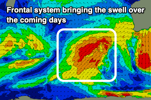 The frontal system is currently south-west of us, generating weakening gale-force W/SW winds that are are now more strong to gale-force in strength but broad in nature.
As the front pushes into us this evening and tomorrow we'll see stormy, onshore surf to the 10ft range across the South West, 3-4ft further north but with strong W/SW-SW winds, easing later in the day as the system starts clearing to the east.
Come Wednesday the groundswell will fill in, maintaining 10ft surf in the South West, 3-4ft across Mandurah and 3ft+ in Perth with the strongest sets to the north seen from midday into the afternoon.
Winds will remain onshore from the W/NW on Wednesday, strengthening a little through the day but we'll see Perth and Mandurah seeing offshore E/NE-NE winds, swinging NW through the day and possibly variable into the late afternoon.
We should finally see winds ease back into Thursday, tending variable across the South West but there'll still be lots of lump with the lack of a true offshore breeze. Perth and Mandurah should see morning NE winds, variable into the afternoon.
Size wise, the South West should still be 8ft most of the day, helped by a reinforcing, mid-period SW swell from a front pushing through on Wednesday.
Mandurah looks to ease from 3ft, similar in Perth with Friday coming in around 2ft (6ft Margs).
A light to moderate, morning NE breeze is due Friday morning, variable into the afternoon again, then NE tending N on Saturday as the swell continues to ease.
Longer term a mid-latitude looks to develop right off our region into early next week, bringing a large, onshore swell, with a secondary possibly forming right on its tail. Extending the run well into the week. More on this and the tricky forecast Wednesday and Friday though.