Nothing major on the weekend, back to back large swells next week

Western Australia Surf Forecast by Craig Brokensha (issued Friday June 11th)
Best Days: Keen surfers across the South West and Mandurah tomorrow morning, Tuesday protected spots, Wednesday in the South West, Thursday
Features of the Forecast (tl;dr)
- Easing background swell tomorrow with light E winds ahead of sea breezes
- Swell bottoming out Sun AM with fresh W/SW winds in the South West, variable to the north
- New mid-period W/SW swell for late Sun in the South West, peaking Mon but with a larger, building swell through the day with strong SW winds
- Easing large SW swell Tue with strong S tending S/SE winds (S/SE-SE early Perth and Mandurah)
- Smaller Wed with light E/SE winds and sea breezes
- Large, long-period SW groundswell arriving late Wed, peaking Thu with E/NE tending N winds
Recap
Wet, solid onshore waves from the north-west tending west yesterday but apart from the early in Perth, conditions were poor for the most part.
Today we've got light, variable winds and cleaner conditions cross all locations, best in Mandurah and Perth with easing 2-3ft and 2ft sets respectively (a little more than expected). Margs is dropping from 4-5ft and has since cleaned up.
This weekend and next week (Jun 12 - 18)
We'll see the current mix of swells continuing to ease back in size through the weekend, dropping from 3ft to maybe 4ft across the South West, 1-2ft in Mandurah and 1-1.5ft across Perth along with light, morning offshore winds.
Winds should stay favourable until early afternoon, then swinging onshore. Winds on Sunday will deteriorate across the South West, onshore from the W/SW from dawn, variable to the north all morning but with no size as the swell drops further.
We may see winds remain variable into the afternoon and some new mid-period swell that's due late in the South West isn't likely to show before dark further north.
This new swell and stronger pulses for early next week are being generated by a frontal progression that's currently just north-east of the Heard Island region. An initial fetch of strong to gale-force W'ly winds will generate later Sunday's swell, with sightly better trailing W/SW gales set to generate a bit more size Monday morning.
The secondary front moving on top of all this activity, generating a larger pulse for Monday afternoon and Tuesday morning now looks to maintain its strength while pushing up and into us on Monday, bringing an earlier increase in swell and more size.
We're now due to see the South West building from the 8ft range early, up to 10ft to possibly 12ft through the afternoon, easing back from 10ft+ on Tuesday morning. Perth and Mandurah look to build from 2-3ft to 3-4ft and 4ft respectively, easing back from a similar size Tuesday morning.
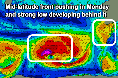 Winds will unfortunately be strong from the SW on Monday as the swell builds, tending S/SW near dark but remaining strong from the S'th into Tuesday morning as the swell eases, tending S/SE through the day. Perth and Mandurah should see S/SE-SE winds in the morning, shifting stronger S/SE through the day.
Wednesday looks the cleanest with light offshore winds and a drop in swell from 5-6ft in the South West, 2ft further north.
Later in the day Wednesday but more so Thursday, a large, new, long-period SW groundswell is expected, generated by a strong polar low firing up south-west of us early next week. A great fetch of severe-gale to storm-force W/SW winds are due, lasting for over 24 hours while moving slowly east.
This swell should kick late Wednesday but peak Thursday to 10-12ft+ in the South West, 3ft across Mandurah and 2-3ft to the north along with offshore E/NE tending variable winds. Following this we may see a smaller though fun backup swell for Sunday, but more on this Monday. Have a great weekend!