Average, better early next week

Western Australia Surf Forecast by Craig Brokensha (issued Wednesday 16th October)
Best Days: Saturday morning for the keen in the South West (similar Sunday), Monday morning all locations, Tuesday morning in the South West
Features of the Forecast (tl;dr)
- Generally small, weak swells with morning SE winds
- Stronger swell due Monday with favourable, offshore winds
Recap
A fun kick in swell with offshore winds across the South West yesterday coming in at 3-4ft, while Perth and Mandurah picked up a bit more size than expected with 1-2ft sets for the keen.
Today the swell has eased with winder conditions, OK for the keen across the South West.
This week and weekend (Oct 17 - 20)
The coming couple of days are looking fairly slow across all regions with the swell easing further in size along with fresh morning SE winds (lighter Friday morning, ahead of strong S/SW sea breezes. There’ll be nowhere to recommend before some new swell moves in for the weekend.
A slight increase in size is due across the South West Saturday from a weak polar front that’s currently south-southwest of us.
This front has been generating strong W/SW winds through our southern swell window, with a similar size pulse of swell to yesterday due across the South West, 3-4ft sets should be seen on the swell magnets, easing through the afternoon, with tiny 1-1.5ft sets max in Perth and Mandurah. Winds will be favourable for selected breaks with a morning SE’ly ahead of strong S/SW sea breezes.
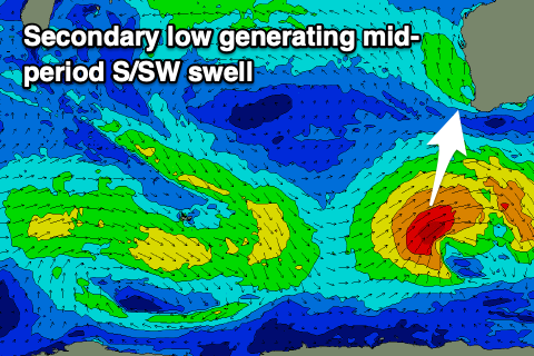
Into Sunday we’re now due to see an inconsistent, building long-period SW groundswell, followed by mid-period and more consistent S/SW energy Monday.
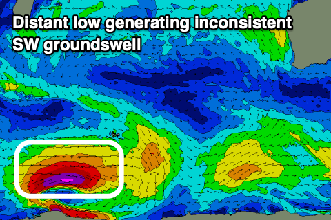 An initial tight low has formed west of Heard Island, with a fetch of severe-gale to storm-force W/SW winds being generated through our far swell window. This will produce a moderate sized, inconsistent long-period SW groundswell for Sunday, building through the day, but a secondary low moving on top of this swell is set to generate weaker, strong to gale-force W/SW winds in our southern swell window, producing a mid-period S/SW swell.
The first swell for Sunday should build slowly to 4ft into the afternoon across the South West but with S/SW sea breezes after morning SE winds.
 Monday looks better with the mid-period S/SW swell filling in as the inconsistent SW groundswell peaks, offering mixed mid-period and long-period 6ft sets in the South West, 2ft in Mandurah and 1-2ft across Perth.
Conditions look much better with an E/SE offshore on Monday, giving into afternoon sea breezes, similar Tuesday as the swell eases.
Longer term the outlook remains slow, so try and make the most of the spike in swell Monday.
Comments
Time warped back to October