Average to poor week, possible swell to keep an eye on

Western Australia Surf Forecast by Craig Brokensha (issued Monday 14th October)
Best Days: Keen surfers tomorrow morning in the South West, similar Saturday morning, next Monday/Tuesday
Recap
A poor weekend of surf all around with small to tiny swells and average conditions across the South West.
This morning there is a touch more swell across the South West but conditions remain poor with a fresh onshore wind. Mandurah and Perth have a little more size as well with cleaner conditions.
This week and weekend (Oct 15 - 20)
We’re in the grips of a poor surf outlook owing to a significant high pressure block setting up right across the southern Indian Ocean. This is linked to a positive Southern Annular Mode event, with it due to persist through the coming week.
With the block across our main swell windows and weak polar frontal activity there’s nothing significant due in the short-medium turn.
A weak mid-latitude low that formed off the South West last night is clearing to the east and with this we’ll see cleaner conditions tomorrow as winds swing around to the E/SE, moderate to fresh in strength.
Size wise mid-period S/SW swell energy doesn’t look to top 3ft across the South West magnets tomorrow, fading Wednesday from a similar size with tiny surf to the north in Perth and Mandurah.
Strong SE winds on Wednesday will create average conditions across the South West with the lack of size, so get in tomorrow morning.
Moving into the end of the week we should see cleaner conditions Friday (after strong SE winds again Thursday morning) but with no swell of substance.
On Saturday a new mid-period S/SW swell should be seen across the South West, generated by a persistent but not overly strong polar front moving through our swell window this week.
 The swell isn’t anything special again with 3ft+ sets due across the South West swell magnets, tiny to the north but conditions look favourable with a morning E/SE-SE breeze.
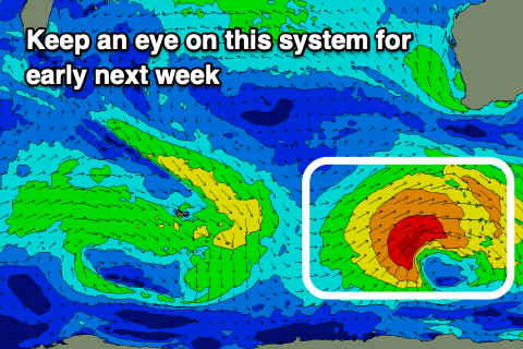
Longer term, a stronger polar low is forecast to develop south-west of us later this week and this has more swell potential attached to it. The models are in agreement regarding some form of storm developing, but at this stage it’ll be S/SW again in direction and moderate to possibly large in size. We’re looking at building surf to 6ft Monday afternoon across the South West, 2ft in Mandurah and 1-2ft in Perth under offshore morning winds and afternoon sea breezes.
Following this the outlook remains subdued so check back here Wednesday and Friday for updates on early next week’s swell.