Mental block

Western Australia Surf Forecast by Craig Brokensha (issued Friday 11th December)
Best Days: Tuesday morning in the South West for the desperate
Recap
Yesterday was the pick of the period with a mix of localised S/SW swell and inconsistent new SW groundswell as winds swung offshore and remained favourable into the afternoon. The South West saw clean 4-5ft sets, with peaky surf to 1-2ft further north.
Today conditions are again clean and warm this morning but the surf has eased, only surfable in the South West and to 3ft.
This weekend and next week (Dec 12 - 18)
The weekend looks void of any quality surf with the swell easing further from yesterday as a window of light S/SE winds early in the South West shifts onshore later morning, clean to the north but tiny.
A new S/SW groundswell is due to build through the day as the onshore winds kick in, generated by a deepening but poorly structured low (for our regions) yesterday. A limited fetch of small W/SW gales were aimed in our swell window, with a small kick to 3-5ft due across the South West, tiny to the north.
A weak trough moving in Sunday will keep winds onshore out of the SW on Sunday, swinging W/SW through the day as the small S/SW groundswell fades.
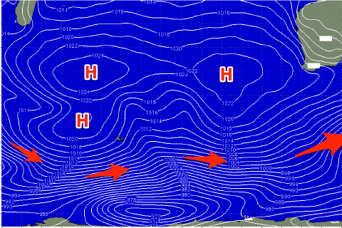 From Monday a broad, elongated and blocking high will move in under us, extending into the Indian Ocean and this will put a block on any major swell generating systems.
Weak polar fronts skirting around the southern flank of the high look to generate some small pulses of mid-period S/SW swell early next week though only to 3ft on the magnets Monday/Tuesday, fading Wednesday.
Winds will slowly improve Monday and swing S/SE, but Tuesday looks best with a morning E/SE offshore ahead of sea breezes.
Wednesday looks a bit hit and miss with stronger SE winds and small, easing surf, poor Thursday as the swell bottoms out.
Late in the week a small, inconsistent S/SW groundswell should fill in across the South West, peaking Saturday morning. It'll be from another weak polar front, but this front looks to have a touch more strength and longevity than the ones before it. As a result the South West may see 3ft to occasionally 4ft sets Saturday morning after arriving late Friday.
Beyond this the outlook remains average with weak polar fronts the only source of swell energy. More on this Monday. Have a great weekend!
Comments
Shame about the lack of swell.

And a pity about that little inside groyne jutting out... word is it was a perfect long right hander for a few months until they added that in!
Farknhell
https://www.9news.com.au/national/great-white-shark-cottesloe-beach-wa-c...
Big boy/mumma.
Fark! .. I mean Shark! .. “ There have been 31 seen since Monday, prompting the closure of 11 beaches”